
Previous section (click the link to return):
←1.1.Ancient cities in the place of modern Odesa♦
From the Goths to the Cumans
In the 2nd-3rd centuries AD, numerous Germanic tribes of the Goths arrived in the territory of modern Ukraine, including Crimea. In the Dnieper region, they defeated the local Slavs (the Antes) and established their state with the center in Danparstad on the right bank of the Dnieper. After the Goths were expelled by the Huns in alliance with the Slavs (in 375 AD), some Goths remained in Crimea and certain areas of Volhynia and Podolia. Remnants of their material culture are still being discovered. In the late 4th to 5th centuries AD, the first state formation in the history of all Slavs was created in the Dnieper region—the state of the Antes. During this time, Kyiv grew from a trading settlement into the first Slavic city.
 In the 6th-7th centuries, the Dnieper region and Crimea fell under the rule of new Turkic tribes—the Avars, followed by the Bulgars, who arrived from the east. In the 8th century, they came under the rule of the Khazar Khaganate.
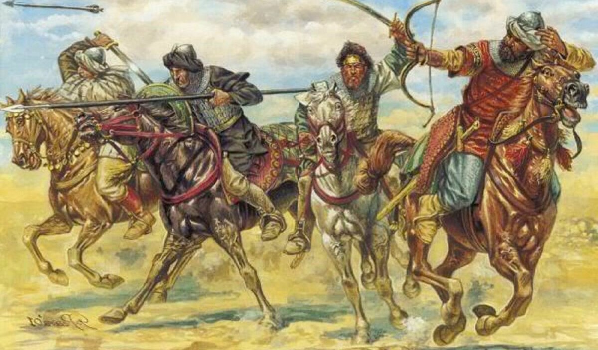
In 1088, the Cuman hordes reached the Danube, led by Khan Tatush. To cross large rivers, the Cumans did not have the necessary watercraft, but this did not stop them. The Jewish traveler Rabbi Petachiah of Regensburg, who visited Desht-i-Kipchak, wrote: «The inhabitants of this land (the Cumans) do not have boats, but they sew together ten stretched horse hides, sew them around the edges with a single strap, and sit on these hides with their carts and loads. Then they tie the ends of the hides with straps to the tails of the horses and let them swim across the river—this is how they cross the river».
The Cumans came to the Danube at the invitation of the Pechenegs, who were engaged in a difficult war with the Byzantine Empire. By the time their allies arrived, the Pechenegs had managed to defeat the Byzantines on their own and capture rich spoils. Learning of this, the Cumans urged the Pechenegs to share the spoils equally. Here is how the Byzantine historian Anna Komnene describes the speech of the Cuman Khan Tatush in a conversation with the Pecheneg elders: «We left our homeland, undertook such a long journey, and came to your aid to share with you both dangers and victories. We fulfilled our duty, and you cannot send us back empty-handed. It was not our fault that we arrived after the battle ended, but rather the emperor’s for hastening to start the fight. So, if you do not share the spoils with us, we will become your enemies, not your allies».
Subsequently, the Cumans firmly established themselves in the Northern Black Sea region, taking control of all of southern Ukraine and most of Crimea. The Cumans played a significant role in the history of Hungary, Rus, Byzantium, and, of course, Crimea, becoming the ancestors of the Crimean Tatar people.
The Antes
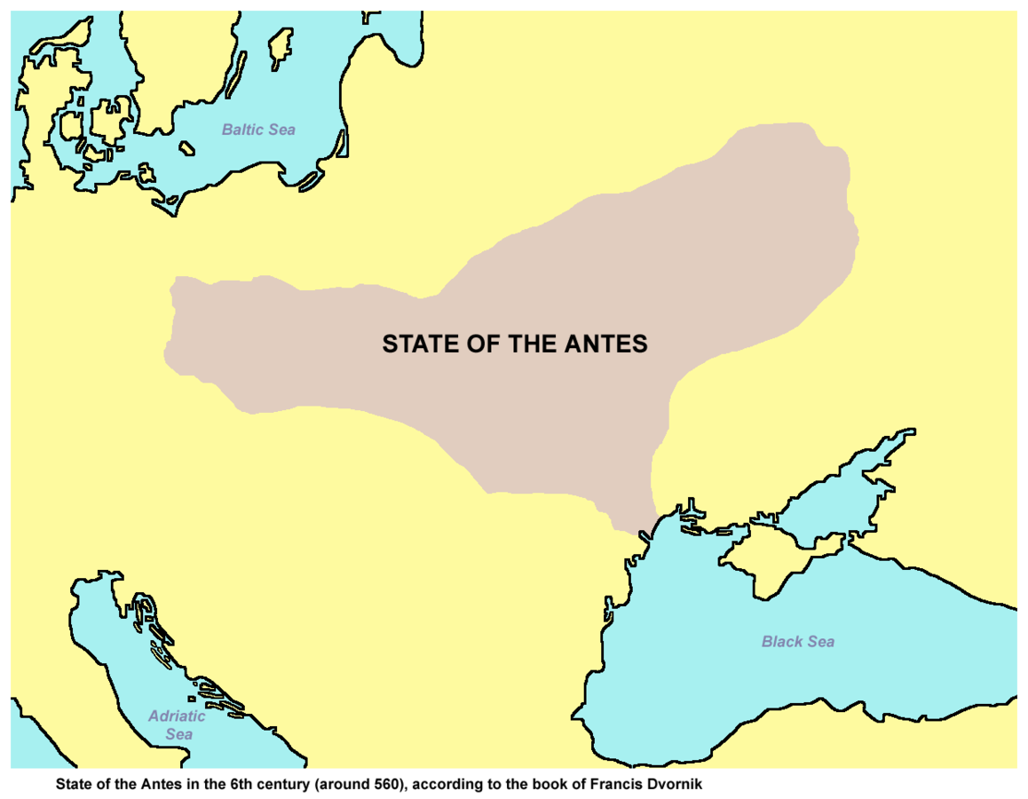
 The earliest information about the Antes can be found in the works of Jordanes and Procopius of Caesarea, dating back to the first half of the 6th century. In these works, as well as in later Byzantine authors (Agathias, Menander, Mauricius Strategos, Theophylact Simocatta), the Antes are mentioned alongside another Slavic group — the Sclaveni. According to Jordanes, the Antes were the strongest among the Slavic tribes. Both Jordanes and Procopius of Caesarea spoke of the shared origins of the Antes and the Sclaveni, emphasizing their similarities in language, lifestyle, and customs. This is also mentioned in the “Strategikon” by Mauricius, a Byzantine author from the late 6th to early 7th centuries: “The tribes of the Slavs and Antes are similar in lifestyle, customs, and love for freedom; they cannot be persuaded to become slaves or subjects in their own land. They are numerous, resilient, and endure heat, cold, rain, nudity, and hunger easily“. According to Jordanes, the Antes inhabited the territory “from the Dniester (Danaster) to the Dnieper (Danaper), where the Pontic (Black) Sea forms a bend.” Procopius of Caesarea also mentions the Antes on the left bank of the lower Danube and east of the Dnieper. Listing the tribes that lived in the North Caucasus, he notes that north of the Utigurs (a Bulgarian tribal union occupying the Eastern Azov territories) were the lands of the countless tribes of the Antes. There are no written records about the northern boundary of the Antes’ settlement, but to the south, they bordered nomadic tribes of the Azov-Black Sea steppes. Thus, it can be concluded that the Antian tribes in the first half of the 6th century were spread across a territory from the Don-Dnieper interfluve in the east to the lower Danube in the southwest. In Jordanes’ work, in addition to contemporary accounts about the Antes, there is also a story about the war between the Antes and the Goths (Ostrogoths) during the Hunnic expansion into the Black Sea region (late 5th century). It should be noted that other authors mention the Antes only in the context of events in the 6th to early 7th centuries.
 The year 518 is considered the beginning of the Antian raids into the Byzantine Empire, which continued with short breaks until 545. The Antes also frequently allied with the Kutrigur Bulgars, who roamed the northern Black Sea steppes, in their campaigns against Byzantium. In the second half of the 6th century, the Antes primarily acted as allies of Byzantium. Separate Antian detachments fought in the Byzantine army even earlier, notably Antian cavalrymen participating in the Byzantine war against the Ostrogoths in Italy from 536 to 540. Some Antes, while in the service of Byzantium, held prominent positions in the Byzantine military. In 531, the leader of the Byzantine troops in Thrace was an Ant by origin named Chilbudius. Procopius of Caesarea also mentions Dabragezas, an Ant who served as a taxiarch (one of the commanders) during the Byzantine-Persian War of 555–556. The military campaigns of the Antes and Sclaveni marked the beginning of the wide Slavic colonization of the Balkan Peninsula (a large-scale movement of Slavic tribes to the Balkans), which continued throughout the mid-6th to 7th centuries.
The last mention of the Antes in written sources dates to 602. It is worth noting that after this date, Byzantine sources largely stop reporting on the southern part of Eastern Europe for a long time.
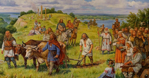
According to written sources, the Antes led a settled lifestyle, engaging in agriculture and animal husbandry. Undoubtedly, crafts, such as fishing and hunting, also played a significant role in the Antian economy, as confirmed by archaeological sources and the location of their settlements along large rivers.
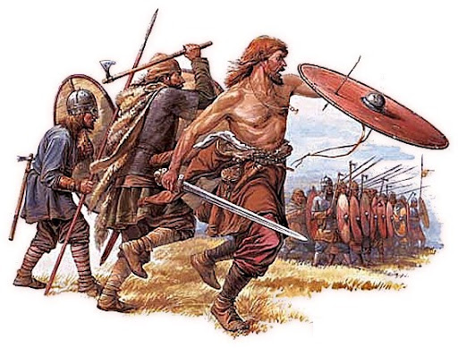
Procopius of Caesarea described the social structure of the Antes as follows: “Neither the Sclaveni nor the Antes are ruled by one man, but they have lived in democracy from ancient times, and thus they resolve all matters, good or bad, collectively“. At the same time, Jordanes, in his account of the war between the Ostrogoths and the Antes at the end of the 4th century, mentions a king (rex) of the Antes named Boz and seventy elders. In Menander Protector’s account, a Byzantine author of the second half of the 6th century, there is a reference to an envoy named Mezamir, who negotiated with the Avars on behalf of the Antes. Meanwhile, in the “Strategikon” written by Mauricius at the end of the 6th – early 7th centuries, it is noted that “they [the Slavs] have many princes, and they are in discord with each other“. These reports reflect the dynamic changes occurring within Antian society. The princes mentioned by Mauricius were likely leaders of military units, while power within settlements apparently belonged to communities. The political development of the Antes was rather contradictory. The degree of political consolidation among the Antian tribes was not constant either. In certain periods, strong leaders emerged who headed the entire Antian union or acted as its representatives in diplomacy, while at other times, princes, who were “in discord with each other,” came to the fore. During military campaigns, a warrior class emerged among the Antes, for whom military affairs became the main occupation. As early as the 530s, Procopius of Caesarea mentioned Slavic, particularly Antian, cavalrymen who fought on the side of Byzantium against the Ostrogoths in Italy. The Antes’ contacts with nomadic unions played an important role in their military-political development
ЦAn interesting account of the beliefs of the Antes and Sclaveni was left by Procopius of Caesarea: “They believe that only one god, the maker of lightning, is lord over all, and to him, they sacrifice bulls and perform sacred rites. They do not know of fate and do not acknowledge that it holds any power over people… They worship rivers, nymphs, and other deities, offering them sacrifices and using these sacrifices for divination“.
According to M.S. Hrushevsky, the Antes are associated with the beginnings of Ukrainian ethnogenesis.
ПThe question of the Antes’ connection to archaeological finds remains somewhat debated. Nevertheless, their association with the Penkovka culture is beyond doubt. According to I.S. Vynokur and O.M. Prykhodniuk, the Antes are also connected to the Kolochin culture and the eastern part of the Prague culture (between the Dnieper and the Western Bug). If this view is correct, the territory of Antian settlement should also include the Pripyat Polesia, the Desna basin, and the southern part of the Upper Dnieper. In the area of the Penkovka and Kolochin cultures (in the territory of the Middle Dnieper and the Left Bank of the Dnieper), during the second-third quarters of the 7th century, rich hoards of silver and bronze jewelry and details of men’s and women’s attire have been found, including belt sets of heraldic style, which were a striking element of the warrior culture. These finds indicate wide cultural ties with Byzantium, Germanic tribes, and the nomadic world.
Kyivan Rus
![]() The first reliable mention of the Rus dates back to the year 839 in the Frankish chronicle The Annals of St. Bertin, which states that the representatives of an embassy that arrived from the north to the Byzantine Empire called themselves Rus. The Rus made their next significant appearance in 860, when they launched a naval raid on Constantinople, plundered the outskirts of the capital, and sailed away unhindered, as described by Greek eyewitnesses.
The first reliable mention of the Rus dates back to the year 839 in the Frankish chronicle The Annals of St. Bertin, which states that the representatives of an embassy that arrived from the north to the Byzantine Empire called themselves Rus. The Rus made their next significant appearance in 860, when they launched a naval raid on Constantinople, plundered the outskirts of the capital, and sailed away unhindered, as described by Greek eyewitnesses.
Researchers link the state-building processes in the Middle Dnipro region with the emergence of the well-known trade route from Scandinavia to Constantinople, known as the “route from the Varangians to the Greeks“. A significant portion of this route ran along the Dnipro River, and Kyiv was an important transit point, allowing control over trade along the Dnipro, Prypiat, and Desna rivers. It also served as a place where traveling Normans would stop to replenish supplies. By the end of the 9th century, under the leadership of the Normans, a new tribal alliance began to form around Kyiv, with the Polans at its core. Notably, the Rus’-Byzantine Treaty of 911, mentioned in Greek sources, confirms the existence of a Viking state on the slopes of the Dnipro River.
From the first half of the 10th century, the first ruler of the Kievan state, confirmed by foreign sources, is known — Igor the Old, whom the “Tale of Bygone Years” refers to as a prince. The chronicle information about the governance of the state during that time is now considered more reliable. The princely retinue played a significant role in the administration, accompanying the rulers on campaigns and collecting tribute from the conquered local Slavic tribes. The collected tribute (furs, honey, skins, wax, slaves) was primarily exported to Byzantium, and the proceeds were spent on purchasing weapons, luxury goods, and wine, which formed the basis of imports. When trade conditions no longer satisfied the prince, he launched an unsuccessful campaign against Constantinople in 941, which resulted in a new Rus’-Byzantine trade agreement in 945. The “Tale of Bygone Years” recounts Igor’s attempts to collect more tribute from the conquered Slavs, which led to a rebellion by the Drevlians, who killed him in 944 or 945. Olga, Igor’s widow, took brutal revenge for her husband’s death. She implemented a tax reform that organized tribute collection and established “pohosty” (places for collecting tribute); she founded diplomatic relations with the German emperor, the Pope, and Byzantium, and she converted to Christianity. In 964, Olga transferred the Kievan principality to Sviatoslav (Igor’s son), who was a militant pagan and spent nearly his entire life on military campaigns — the last “true Varangian” on the princely throne. He subjugated the Vyatichis, Yasis, and Kasogs, and defeated the Khazar Khaganate, a state formation of the Khazars in the east; he waged successful wars against the Bulgarians and Byzantium, even considering relocating the capital of his state to Pereyaslavets. However, in 971, he was besieged in the fortress of Dorostol, which forced him to cede the conquered lands and return to Kyiv. On the way, near the Dnieper rapids, he was killed by the Pechenegs, who were in collusion with the emperor. Dividing the lands of Rus among his three sons (Yaropolk, Oleg, and Volodymyr) led to the first civil war after Sviatoslav’s death, from which Volodymyr emerged victorious. During the reign of Volodymyr Sviatoslavich (978–1015), Rus significantly expanded through the conquest and annexation of Red Ruthenia, Transcarpathia, and Korsun. Thus, Kievan Rus became the largest state in Europe, with a population of over 5 million people and an area of 800,000 km². The socio-economic structure of the state did not differ from that of other contemporary European states. Its foundation consisted of subsistence agriculture, communal land ownership, slash-and-burn farming, and pastoralism. Volodymyr implemented a reform of local self-government by abolishing tribal autonomies and appointing his own governors. In 988, Volodymyr announced the acceptance of Christianity from Byzantium, baptized the inhabitants of Kyiv in the Pochaiv River, built the first stone church, the Church of the Tithes, and introduced the “Statute on Church Courts and Tithes.” Unlike the attempts of Olga and Askold, this had a profound impact on broad segments of the population and was a decisive step in the further history of Ukrainian lands. He conducted administrative, monetary, and military reforms: he appointed governors and his sons in major cities, minted his own gold and silver coins, and distributed border lands to loyal vassals in exchange for organizing defense. It was on Volodymyr’s orders that a system of fortifications, known among the people as the “Serpent Mounds“, was constructed, stretching for 1,000 km.
Despite these significant changes and strengthening of the state structure, after Volodymyr’s death, Rus entered a period of internal strife from 1015 to 1019. Yaroslav the Wise (1019–1054) emerged victorious in the struggle against his brothers, ruling Rus jointly with his brother Mstyslav until 1036. This ruler decisively defeated the Pechenegs, who had long caused considerable damage to Kievan Rus, and built the Saint Sophia Cathedral in Kyiv at that location, which still stands today. Between 1037 and 1039, the first chronicle was created, and the first book workshops were established. The Kyiv-Pechersk Lavra was founded, and Hilarion was elected as the Metropolitan of Kyiv. A judicial reform was implemented, introducing the first collection of laws in Rus—”Rus’ Truth“. In the south, he annexed the lands of Porossia, and in the west, several territories of the Polish Kingdom. Yaroslav the Wise widely employed marriage diplomacy, actively marrying his daughters to European rulers.
The death of Yaroslav the Wise in 1054 ushered in a new period of infighting among his sons (Iziaslav, Sviatoslav, and Vsevolod). The practice of convening assemblies to develop legislation became a regular occurrence, resulting in the document known as the “Truth of the Yaroslavichs” in 1072. In 1097, Volodymyr Monomakh convened a council of princes in Lyubech, where a new hereditary principle of succession to the princely throne was established, solidifying feudal fragmentation. For a time, this process was halted by Volodymyr Monomakh, who was invited to the throne by the people of Kyiv after the uprising of 1113. During his reign, the first bridge across the Dnipro River was built. He developed an addition to the “Rus’ Truth” known as the “Statute.” Through skillful military and diplomatic actions, he controlled two-thirds of Yaroslav’s state and actively defended the city from incursions by the Cumans.
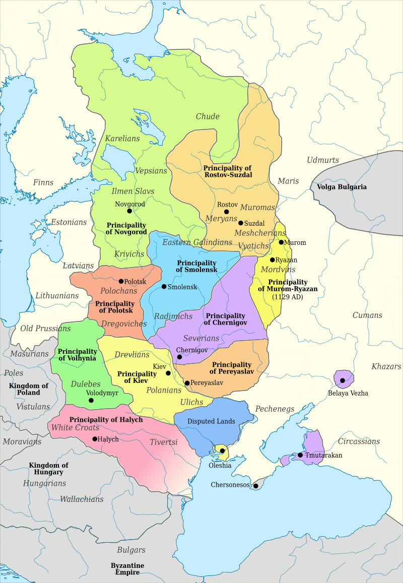
After the death of Mstyslav, the eldest son of Volodymyr Monomakh, in 1132, Rus’ definitively lost its unity. By the mid-12th century, about 15 large appanage principalities had formed on the territory of the once unified state, each living essentially an independent political life while nominally recognizing the primacy of the Grand Prince of Kyiv. On the territory of modern Ukraine, these included: Kyiv, Chernihiv, Pereiaslav, Volyn, and Halych. In later chronicles, this period is noted as the first instance of the toponym “Ukraine” being dated to 1187. An active struggle for power began. According to Ukrainian historian Stepan Tomashivskyi, from 1146 to 1246, the rulers of Kyiv changed 47 times; returning to the throne multiple times, 24 princes ruled here, with 35 principalities lasting less than a year each. The main forces of opposition in Ukrainian lands included the Rus’ families: the Olhovychi of Siversk, the Mstyslavichi of Volyn, the Rostyslavichi of Halych, and the Polovtsian clans—the Olberlyuevy of Donetsk, the Tertrovychy of the Azov region, and the Kaievychy of the Dnipro region.
Halych-Volhynian Principality
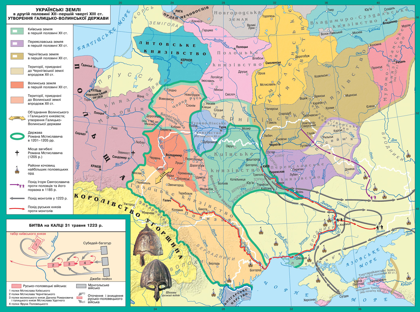
 The Principality of Halych separated from Kyiv in 1097 and reached its peak during the reign of Yaroslav Osmomysl (1153–1187), the Prince of Halych, who built a powerful state, developed cities, and fought against the Cumans. Under his rule, the principality extended to the Danube and the Black Sea, and successfully waged wars against the Hungarians and Poles. The principalities of Halych and Volhynia existed separately, but in 1199, Volhynian Prince Roman Mstyslavych captured Halych and created the unified Halych-Volhynian Principality. In 1203, he also seized Kyiv, which had lost its significance after being devastated by Andrey Bogolyubsky in 1169. By that time, Prince Roman had established a powerful state, and Pope Innocent III offered him the title of King of Rus’ if he converted to Catholicism, but Roman declined. After his death during a campaign in Poland, from 1205 to 1238, the oligarchic boyar elite dominated the state. In 1238, Roman’s son, Danylo of Halych, returning from Hungarian exile, seized Halych and became the full ruler of the principality. After the Mongol campaigns in Central Europe, he decisively defeated the boyar opposition in the Battle of Yaroslav in 1245. Having received a patent (yarlik) from the Mongols to rule, he rebuilt fortresses, erected the walls of Kremenets and Kholm, and moved his capital to the latter. After fortifying his position, he began a war against the Mongols in 1252. Seeking assistance, in 1253 he accepted the royal crown from Pope Innocent IV in Dorohychyn, who declared a crusade against the Mongols, which ultimately never materialized. As a result, Danylo refused to admit Catholic missionaries and severed ties with the papal curia. Danylo of Halych participated in the war for the Austrian throne, conducted military campaigns against Bohemia, Poland, Lithuania, and the land of the Yotvingians, but in 1258, he submitted to Mongol authority, renewed the patent for his rule, and destroyed the fortifications of his cities.
After Danylo’s death in 1264, his son, Lev Danylovych (1264–1301), ascended the throne. He moved the capital to the newly founded city of Lviv, waged wars with the Hungarians (annexing Mukachevo) and the Poles (seizing the Lublin land). After Lev’s death, his son, Yuriy I (1301–1308), took the throne. He lost the Lublin land, moved the capital to Volodymyr-Volynskyi, titled himself “King of Rus, Prince of Volhynia,” formed an alliance with the Teutonic Order against other Slavic principalities, and in 1303 founded the Orthodox Galician Metropolis. In 1325, Polish prince Bolesław Trojdenowicz, known as Yuriy II Boleslav, was invited to the throne, during whose reign the active Polonization of Ukrainian lands began. In 1340, with the poisoning of Yuriy II by discontented boyars, the united Galicia-Volhynia state ceased to exist.
Gniezno State. Kingdom of Poland
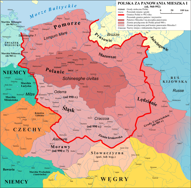
 Civitas Schinesghe (in Latin – Polonia, in Polish – Ziemia Polska) is the first recorded name associated with Poland as a political entity (the name being a Latinization of “hrady knezske” or “grody książęce,” meaning “ducal forts/oppidia”), first documented in 991 (992). The original act is missing, but it is mentioned in the papal registers of the 11th century under the title “Dagome iudex”. It states that a prince from the Piast dynasty, Mieszko I, ruled “unam civitatem in integro, que vocatur Schinesghe” (“an entire state called Schinesghe”). Although the state of Poland is not explicitly mentioned, the name “Schinesghe” most likely refers to Gniezno, one of the main settlements of the Western Slavic tribe, the Polans. Their prince, Mieszko, converted to Christianity after marrying the Bohemian princess Doubrava in 966. In 1000, during the Congress of Gniezno, the first Polish archdiocese was established, and Mieszko’s son, Prince Bolesław I the Brave, was recognized by Emperor Otto III, the Holy Roman Emperor, as a co-ruler.
Mieszko I and his successor, Bolesław I the Brave (967–1025), united Polish lands through struggles against German rulers. In the west, they fought the Holy Roman Empire for control of Pomerania; in the south, they annexed Silesia and Lesser Poland with Kraków through conflicts with Bohemia; and in the east, they faced the consolidation efforts of Kyivan Rus, which was uniting the East Slavic tribes (with Cherven Towns and Przemyśl shifting hands multiple times). In 1025, Bolesław I the Brave was crowned, and the state became known as the Kingdom of Poland. Exercising ducal authority, the ruler imposed taxes and obligations on the population, promoted crafts, and strengthened fortified centers—known as “grody.” Over time, a class of landowners (magnates) and knightly nobility (szlachta) emerged from the princely retinue, while the peasantry—known as “kmiecie”—was directly subject to the king. The needs of state governance led to the creation of provinces and their administrative apparatus. The capital was first Gniezno, then Poznań, and from the mid-11th century, Kraków.
After Bolesław I the Brave, a struggle for the throne began among his heirs, coinciding with the rise of magnates and feudal knights. As a result of these internal conflicts, numerous small duchies emerged, and German states, along with the Baltic tribes — Prussians and Yotvingians — further encroached on Polish lands. To fend off the Yotvingians, Duke Konrad I of Masovia invited the Teutonic Knights to his lands in 1226. Soon, together with the Livonian Order, they established their own state and began seizing territories with Slavic and Baltic populations, supported by the Empire and the papacy. In the mid-13th century, the Mongol-Tatars ravaged the land but were unable to establish control. Duke Władysław I Łokietek of Kuyavia (1260–1333) managed to unite most of the duchies under his rule by various means and in 1320, he obtained the crown. His policies of unification and consolidation were continued by Casimir III the Great (1310–1370), who significantly strengthened royal power: he divided the country into voivodeships and castellanies, reformed the currency, and pursued an active foreign policy. He was the last of the Piast dynasty. He was succeeded by the Hungarian King Louis I the Great of the Anjou dynasty (1326–1382), who was married to Casimir’s sister. Louis generously granted privileges to towns and the nobility, seeking to strengthen his position.
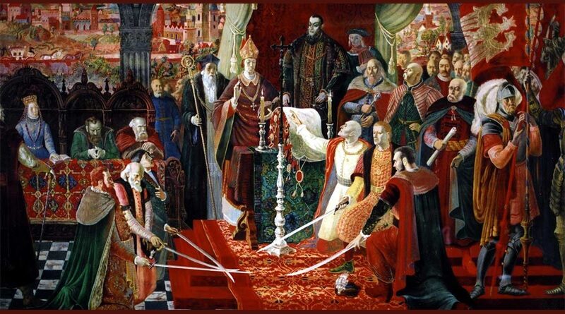
After his death, Poland and Lithuania entered into the Union of Krewo (1385), and Grand Duke Jogaila, marrying Louis I the Great’s daughter, Jadwiga, converted to Catholicism and, under the name King Władysław II Jagiełło (1362–1434), ruled Poland and the Grand Duchy of Lithuania, founding the Jagiellonian dynasty. Under his leadership, in July 1410, the Polish-Lithuanian army, with the support of forces from Rus’ and Bohemia, delivered a crushing defeat to the Teutonic Order’s army, which had allied with the rulers of 12 European countries, at the Battle of Grunwald. This defeat, along with the subsequent Thirteen Years’ War, broke the Order’s power and allowed Poland to annex Eastern Pomerania, parts of Prussia, and gain access to the Baltic Sea. Władysław II Jagiełło and his successors continued to fight the Germans in the west, but increasingly turned their attention to the east. In the 15th century, Poles united in repelling the Turkish invaders, and the Jagiellonians ascended the thrones of Bohemia and Hungary. Within the country, the kings granted more and more privileges to the nobility, including the Nieszawa Privilege of 1454, issued by King Casimir IV Jagiellon, which effectively subordinated the king to the nobility. In the 15th century, an estate-representative monarchy emerged (a form of governance in a centralized state where the monarch’s power is supported by representative bodies of the estates, serving as a transitional phase between feudal monarchy and absolute monarchy). In 1505, King Alexander introduced a collection of laws known as the Radom Constitution (Nihil Novi), which limited royal power in favor of the magnates and nobility, and prohibited the king from making any changes in the state without the approval of the Sejm.
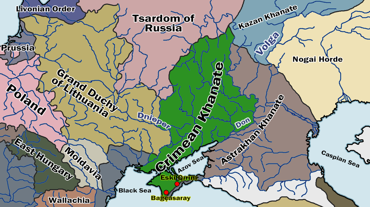
The Golden Horde
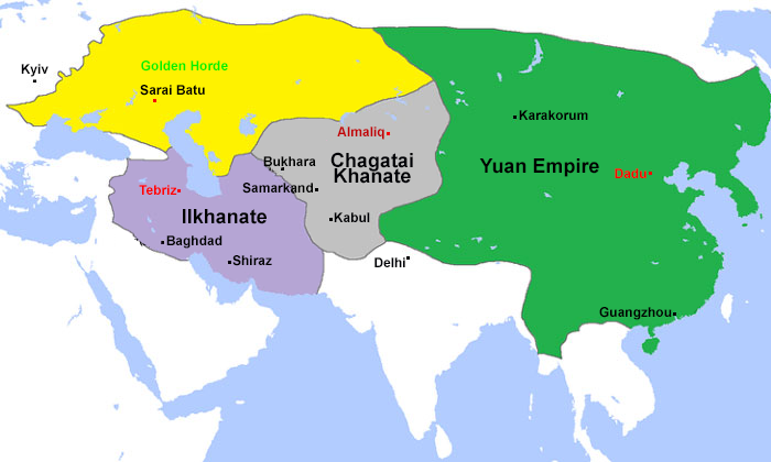 In the early 13th century, a powerful Mongol state emerged and rapidly developed under the leadership of Genghis Khan. After his death, it fragmented into several large dominions, or uluses, which eventually became independent states. The largest Western ulus, founded by Khan Batu, the grandson of Genghis Khan, later became known as the Golden Horde. It was one of the most powerful states in Europe and Asia for over two hundred years. The character of the Golden Horde’s culture, shaped by the political, economic, and social life of the state, was defined by the interaction between the culture of the steppe nomads and the syncretic culture of the cities. In addition to the Mongol-Tatars, the cities of the Golden Horde were inhabited by Cumans, Bulgarians, Russians, people from Western Europe, Central Asia, Crimea, the Caucasus, and others. The center of the Golden Horde was the lower Volga region, where Batu founded the capital, Sarai-Batu, near modern Astrakhan (then Hajji-Tarkhan). During the reign of Khan Uzbek, the capital was moved to Sarai-Berke (a city founded by Batu’s brother, Khan Berke, 1255-1266) near modern Volgograd. In the 1250s, the Golden Horde became fully independent from the Mongol Empire. The head of the Golden Horde was a khan from the lineage of Genghis Khan. To address the most important issues, the khan convened a council of dynasty members—the kurultai. The political system of the Golden Horde had a semi-military character, which was reflected in its administrative structure. The Golden Horde was divided into uluses, regions, districts (tumans), thousands, hundreds, and tens. The heads of administrative-territorial units were beks, temniks, thousanders, centurions, and decurions, who were simultaneously rulers and military leaders.
The distinguished Golden Horde military leader and statesman, Beklyarbek Nogai (1235/1240 — 1300), established a semi-autonomous state formation in the lands between Dobruja (now a province of Romania) and the lower Dnieper—the Western ulus—in the late 13th century. At the turn of the century, Nogai became so confident in his power that he even dared to challenge the Golden Horde. To the northeast of the current Kotovskyi residential area, on the shores of the Kuyalnik Estuary, a great battle took place between the Golden Horde Khan Tokhta and Nogai. The Kuyalnik Estuary (in Tatar, Kuganlyk) was at the very center of Nogai’s possessions. In 1300, his troops met here with the warriors of Khan Tokhta. A significant battle ensued, the outcome of which was decided by the betrayal of several of Nogai’s commanders. Tokhta emerged victorious. The Battle of Kuyalnik had a great impact on the historical destinies of the entire Golden Horde and other states of Eastern Europe. Tokhta united the Horde and ended internal strife in the khanate for a long time. After the victory over Nogai, Khan Tokhta entrusted the Danubian lands to the governance of his son Ilbasar.
The Creation of the Moldavian Principality
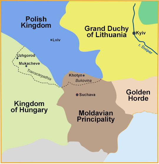
At the beginning of the 6th century, Slavic tribes (the Antes and Sclaveni) settled on the left bank of the Danube, living alongside the local Romanized Geto-Thracian population, who were later assimilated. As a result, by the 10th century, the Eastern Romance ethnic community of the Vlachs emerged — the ancestors of the Romanians and Moldovans.
From the 9th century, eastern Slavic tribes of the Tivertsi began settling in Moldova, followed by the Ulychi, who founded cities like Peresechen, Tegyn, and Bilhorod. From the 10th century, Moldova was part of Kyivan Rus, and in the 12th-13th centuries, it belonged to the Kingdom of Galicia–Volhynia. Trade routes from Galicia to the Black Sea passed through Moldova. Galician merchants founded the city of Malyi Halych (now Galați) on the Danube. Peasant fugitives and other social groups from the Kingdom of Galicia–Volhynia, known as the Berladniks, migrated to the lower Danube, forming the Berlad Principality with cities like Berlad, Tecur, and Malyi Halych.
In the 11th-12th centuries, the territory of modern Romania and Moldova was subjected to raids by nomadic tribes, such as the Pechenegs and Cumans, and in the 13th century, it experienced the Mongol-Tatar invasion. Moldova and parts of Wallachia came under the rule of the Golden Horde, becoming part of its Western Ulus. In the 12th-13th centuries, the Vlachs settled in the Eastern Carpathians, gradually assimilating the indigenous Slavic population and Ruthenian settlers from the Galician lands. Later, the Vlachs expanded into the southern regions of Galicia..
The event that marked the beginning of the expulsion of the Tatars from the territory of the Western Ulus is described in the ancient Russian work “Short Stories about the Moldavian Lord,” which is included in the Resurrection Chronicle. After the death of Uzbeg in 1341, the Western Ulus was handed over to his son-in-law, Atlameș. Atlameș’s brief rule coincided with difficult years for the Golden Horde. The rapid spread of the plague led to significant losses among the population of the Golden Horde. Taking advantage of this, the Transylvanian Székelys (Hungarians), led by András Lackfi, attacked Atlameș’s army and won a victory in the battle (1345), during which Atlameș was killed.
In the anonymous Hungarian source “The Life and Deeds of Louis,” some details of this battle are mentioned: «Having met them on the battlefield, they defeated them along with their prince named Atlamish, and this prince was beheaded… After that, the Székelys began to frequently attack the Tatars and return home with great plunder. And those Tatars who survived fled to distant coastal regions to join other Tatars». Apparently, by “distant coastal regions,” the author meant the lands of the Northern Black Sea region — the Dniester-Dnieper interfluve.
Soon after Laţcu’s victory, vassal Wallachian tribes from Hungary began a gradual migration northward into Bessarabia. According to legend recorded in the chronicle, Hungarian King Vladislav defeated local Tatar prince Neimeta. Among the Hungarian army was a detachment of Vlachs under the command of their leader, Dragos, who asked the king to grant him the lands of the defeated Tatars.
In the interfluve between the Prut and Dniester rivers, besides the Tatars, the Vlachs encountered Galician Rusyns who had been living in these areas since the 11th-12th centuries. Archaeological findings, including Galician-style ceramics, testify to this. Even in major cities of the Western ulus, such as Shehr al-Jedid (Old Orhei, Moldova), there were large communities of Galician craftsmen..
Around 1359, the migration of Vlachs led to the establishment of the Principality of Moldavia. Judging from the preserved evidence of material culture, the ethnogenesis of Moldovans occurred as a result of the mixing of Vlachs with Galician Rusyns and Tatars, some of whom converted to Orthodox Christianity. This is confirmed by research published by Moldovan historian N. Russev.
The founder of the Moldavian state is considered to be Voivode Bogdan. Very little is known about Bogdan. Judging by his name, he might have come from Eastern Europe or Bulgaria, and it’s also possible that he hailed from a mixed Vlach-Slavic family. The Hungarian chronicle of King Louis I mentions him: «Bogdan, the voivode of the Vlachs from Maramureș, gathered the Vlachs of that region and secretly moved onto the land of Moldavia, which was subordinated to the Hungarian crown but long abandoned by its inhabitants due to neighboring Tatars. Despite having to repeatedly battle the king’s army, he prevailed. The Vlachs who populated this land increased in number, and it transformed into a kingdom».
In another document, the Hungarian charter of 1365, it is stated that Bogdan, together with his sons «secretly moved from our kingdom to our mentioned Moldovan land, trying to keep it to the shame of our greatness». It is interesting that Muslim sources for a long time referred to Moldavia as Bogdan’s state. Apparently, the formation of the Moldavian state occurred with direct or indirect support from the Tatar emirs of the Northern Black Sea region. This may be related to the power struggle that unfolded at that time in the Golden Horde. Some supporters of Khan Tokhtamysh after his defeat in the war against Timur «went to the Wallachians and Russians (Bessarabian Rusyns) and due to her unhappy and changeable fate found herself among the godless Christians and captive Muslims… The name of this unit is Karabogdan».
In the second half of the 14th century, the Principality of Moldavia gradually advances towards the Black Sea. Around 1386, Moldavians take control of Akkerman (Bilhorod-Dnistrovskyi, Moncastro). From this period onwards, it is already referred to as Cetatea Albă, although in 1380 it was marked on the Soler map under a Turkish tamga. During this period, part of the Muslim population moves eastward, while a significant portion of the Budjak territory, until the beginning of the 15th century, continues to be occupied by Tatar nomadic camps as before.
In 1359, Golden Horde Khan Muhammad Berdi Beg was assassinated as a result of a conspiracy. This event marked the beginning of a series of civil wars that led to the destabilization of the Jochid Ulus.
The Grand Duchy of Lithuania
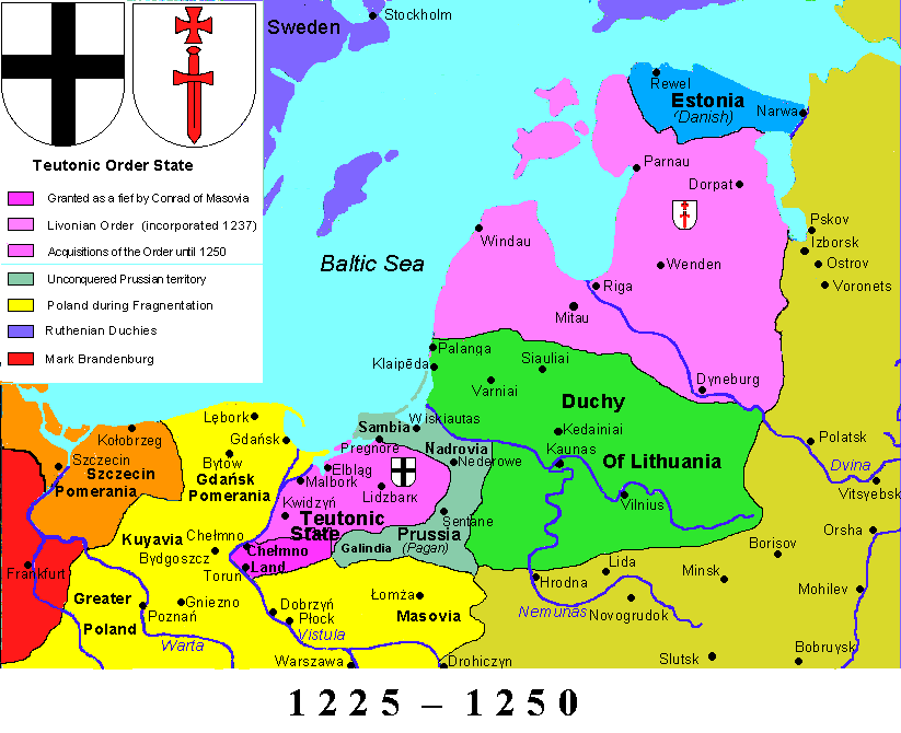
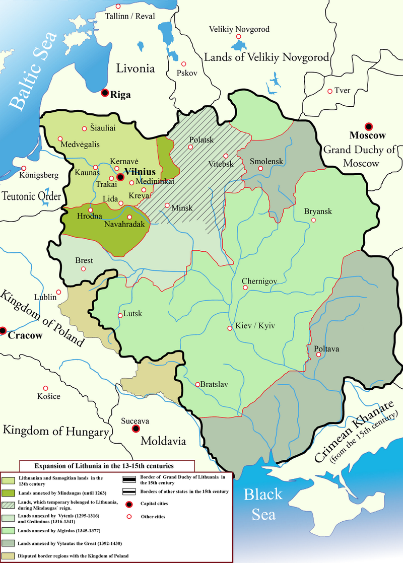
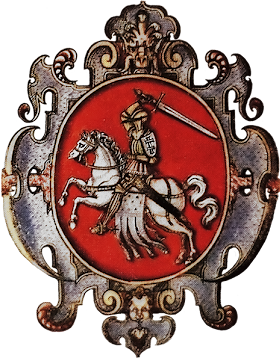
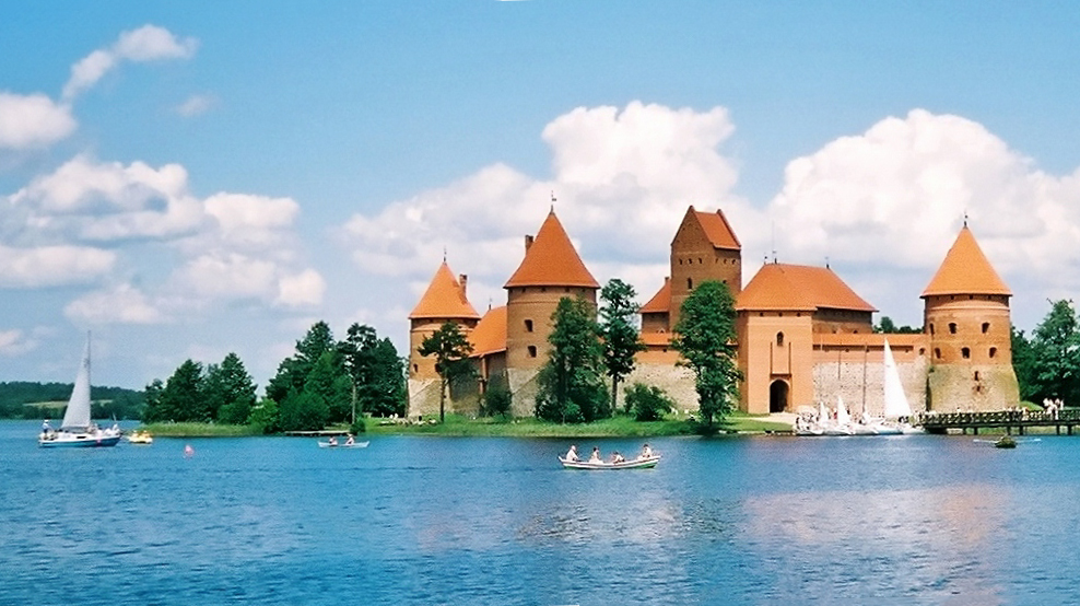 Starting from the 13th century in Neman, in the struggle against the German knight-crusaders (the Teutonic and Livonian Orders) and the Galician-Volhynian princes, the Lithuanian state began to take shape. The first chronicle mention in the Galician-Volhynian Chronicle dates to 1219. One of the primary objectives for the creation of the Grand Duchy of Lithuania was to unite the Eastern Baltic tribes (Aukštaitians, Samogitians (Žemaitians), part of the Yotvingians, Curonians) and the Ruthenians to defend against the growing German expansion and the spread of Catholicism. The founder of the duchy is considered to be Prince Mindaugas (1219–1263), who, during the 1230s-1240s, united part of the Eastern Baltic tribes, annexed Black Ruthenia with its cities (Volkovysk, Slonim, and Novogrudok), and was ceremonially crowned in 1253 in its central city of Novogrudok. Later, none of the rulers of the Grand Duchy were crowned, although the issue of a Lithuanian crown was actively discussed, especially during the reign of Vytautas. Mindaugas added part of the Turov-Pinsk and Polotsk lands with the cities of Grodno, Polotsk, and Vitebsk to his state, and led campaigns against Smolensk and Chernihiv.
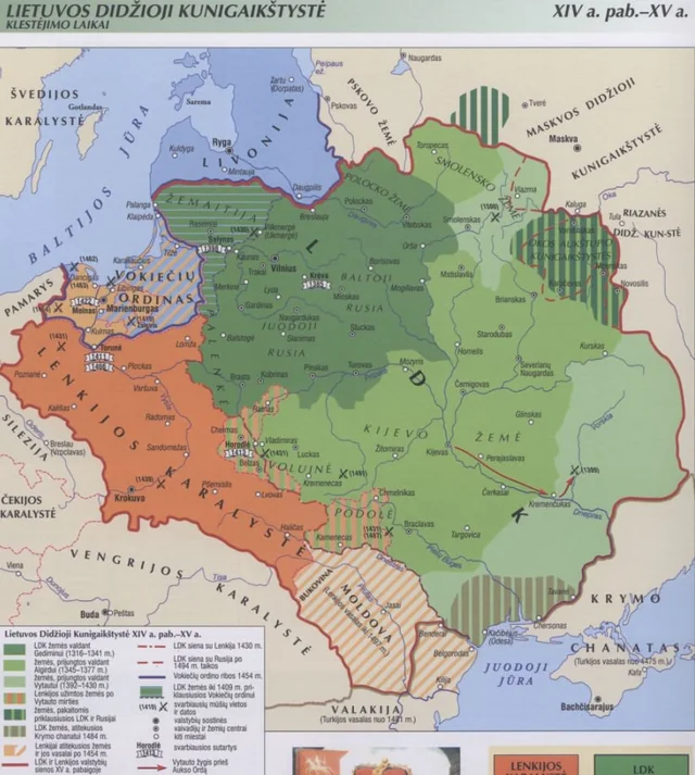
In the 14th century, Lithuanian princes from the Gediminid dynasty successfully took advantage of the decline of the Golden Horde during the process of gathering and redistributing Ruthenian lands devastated by Batu’s invasion in the mid-13th century. The ratio of Slavic to Lithuanian lands within the Grand Duchy in 1341 was 2.5 to 1, and by 1430, it was 12 to 1. Under Gediminas (1316–1341), the territorial unity of the Grand Duchy was strengthened (with Minsk, Orsha, Brest, Pinsk, and Turov joining, and attempts made to annex the Principality of Kyiv), and the hereditary nature of princely power was established. The “Lithuanian Chronicle” states that in 1322, Gediminas seized Zhytomyr, Kyiv, Kaniv, Cherkasy, Bryansk, and Pereyaslav. That year, the Battle of the Irpin River took place three miles from Kyiv, with the Rus’ forces including Prince Oleg of Pereyaslav, Prince Lev of Lutsk, Roman of Bryansk with his knights and troops, Stanislav, Prince of Kyiv, and the Tatars. As a result of Lithuania’s victory, Gediminas appointed his relative Mindaugas Holszański as the senior governor. Stanislav and Roman fled to Ryazan.
In 1340, the Lithuanian prince Liubartas Gediminaitis (baptized as Dmytro) took control of Volhynia. The main portion of Ukrainian lands was annexed to Lithuania during the reign of Algirdas. He annexed the Chernihiv-Siversk lands (1357–1358), Podillia (1363), and the Kyiv lands (1362–1363), defeating the Tatars at the Battle of Blue Waters in 1362. New territories were incorporated through both conquest and peaceful initiatives (agreements, marital and family alliances), with the latter predominating. The consolidation of Lithuanian and Belarusian-Ukrainian political forces was relatively voluntary. Lithuanian princes replaced the Rurikids in the process of uniting the Rus’ principalities. They acted according to the principle of “introducing nothing new, changing nothing old“, actively adopting Rus’ culture, including law (the “Ruska Pravda”), language, and Orthodoxy, and frequently marrying into Rus’ nobility. The Grand Duchy of Lithuania became one of the largest states in Europe. It was a union of many lands, with power in the hands of the local nobility under the supreme authority of the Grand Duke. The element of conquest present in such annexations is sometimes minimized by historians due to Lithuania’s anti-Horde policies and traditionalism. However, the more historically accurate view is that the relationship between the rulers of the Grand Duchy of Lithuania and the Golden Horde was contractual, resulting in the creation of a Lithuanian-Tatar condominium (joint rule) over the lands of the former Kyivan Rus. Lithuania’s political system in the 14th century had elements of a dyarchy—a dual rule by rulers who reigned in Vilnius and Trakai. Only at the end of the century did Vilnius finally secure its status as the capital city.
From 1381 to 1384, the first civil war for power between the descendants of Gediminas took place in the Grand Duchy of Lithuania. It ended in a compromise that, however, satisfied neither side. In 1384, the coat of arms “Pahonia” became the state emblem.
To strengthen the internal and external political position of the duchy in its struggle against the expansion of the Teutonic Order, and to enhance state power and centralization, on August 14, 1385, Prince Jogaila signed the Union of Krewo with Poland—a marriage contract by which Jogaila converted to Catholicism and became the King of Poland under the name Władysław II (1386–1432). Jogaila did not succeed in creating a unified state, but the union initiated a process of closer relations between the Grand Duchy of Lithuania and Poland, and the gradual reduction of the influence of Ruthenian elements in the state, which became even more apparent after the ruling elite converted to Catholicism in 1386. The process of Christianizing Lithuania dragged on for many years, with Samogitia being the last region to convert in 1414.
Dissatisfaction among part of the Lithuanian-Ruthenian nobility with the growing ties to Poland led to the beginning of the second civil war. As a result of the Ostrów Agreement of 1392, Jogaila’s cousin, Vytautas Kęstutaitis (1392–1430), became Jogaila’s governor in Lithuania (from 1395, he used the title Grand Duke of Lithuania). Vytautas pursued a state policy of “grand princely rule over all Rus’ lands,” centralized power, replaced local princes with governors, and abolished the principalities of Kyiv, Podillia, Novgorod-Siverskyi, and Chernihiv. At the end of the 14th century, Khan Tokhtamysh formally revoked the subordination of Rus’ lands under Vytautas’ rule to the Horde by issuing a special yarlyk. Vytautas built a system of defensive fortifications in the southern Ukrainian lands (in Bratslav, Cherkasy, and others), established fortresses in the southern steppes (Dniester Estuary), and in 1397–1398, led two victorious campaigns against the Golden Horde. During Vytautas’ reign, Ukrainian territorial colonization significantly expanded southward and eastward, reaching the Black Sea
From 1398, the Lithuanian state was officially called the Grand Duchy of Lithuania, Ruthenia, and Samogitia.
The struggle for influence over the Northern Black Sea region
 In the mid-14th century, the northern coast of the Black Sea became a battleground for influence among several European states. The Grand Duchy of Lithuania, taking advantage of the weakening Golden Horde, sought to seize control of Kyiv and capture Western Podolia. Around 1362, Grand Duke Algirdas of Lithuania conducted a successful campaign against the Tatars, culminating in the Battle of Blue Waters (Syni Vody). During this battle, Algirdas managed to defeat the forces of three emirs who controlled the lands of present-day southern Ukraine—Kotlubei, Hojbey, and Demir (Demetrius). It is likely that Algirdas faced a relatively small army of the Western Ulus led by Emir (Noyon) Demir (Demetrius) and the chiliarchs Hojbey and Kutlubei. The Tatar detachment was defeated, and no aid came from Khan Murad, who had recently ascended to the throne.
The ulus of Emir Hojbey was located between the Dniester and Southern Bug rivers. It is believed that during the internecine conflicts that engulfed the Golden Horde, Hojbey transformed his ulus into a semi-independent state. Ukrainian historian Yaroslav Dashkevych wrote about this: “The localization of Hojbey’s state is not particularly doubtful—it is the coastal region of the then ‘Great’ Podolia.” The emir’s headquarters were located at the site of present-day Odesa.
According to 16th-century Polish historians S. Sarnicki and M. Stryjkowski, the name of the port and city of Khadjibey (Kachibey) and the Khadjibey (Katibey) estuary originates from the name of one of the emirs, a participant in the Battle of Blue Waters, Hojbey. In “Description of Old and New Poland,” Sarnicki reports: “Advancing with his troops to the Borysthenes and its mouth, he (Grand Duke Algirdas) destroyed all the Tatar fortifications and three of their princes, Kadlubach, Demetrius, and Kachibey, from whom the port of Kachibey is named; his army was destroyed.“.
According to the research of Serbian historian Aleksandar Uzelac, who studied the archives of Da Ponzi, an Italian notary in Kiliya, in 1361, Demir and Khadjibey (referred to as Hojja in Da Ponzi’s document) were actively involved in the slave trade in the region. Da Ponzi’s documents also mention a previously unknown town or large settlement called Jawara, which was likely under the control of “Hojja the Thousandman” It can be assumed that this is the earliest reference to the city of Khadjibey (Odessa), which shortly after the Battle of Blue Waters was named after its suzerain, Hojja the Thousandman. This historical figure will be mentioned repeatedly in documents until the late 1380s.
Stryjkowski writes about this same battle: “Unable to withstand the frontal assault of the Lithuanians any longer, the Tatars began to intermingle and, panic-stricken, fled to the vast fields. Three of their rulers were killed on the battlefield: Kutlubach, Khadjibey (after whom the Khadjibey Salt Lake in the Wild Fields on the way to Ochakov is named), and Sultan Dimeyter, along with many murzas and ulans.” In the “Kachibey Salt Lake” it is easy to recognize the present-day Khadjibey Estuary. It is reasonable to assume that the name of the Tatar emir was given not only to the estuary but also to the settlement, which at that time was the administrative center of the small ulus ruled by Emir Khadjibey. It should be noted that during archaeological excavations in Odessa, Golden Horde ceramics have been found repeatedly.
 These reports are corroborated by archaeological findings made in Odessa by the expedition of A. Krasnozhon and A. Dobrolyubsky at the end of the 1990s. They discovered Golden Horde red-yellow-striped pottery from the mid-14th century at the site of the presumed medieval settlement.
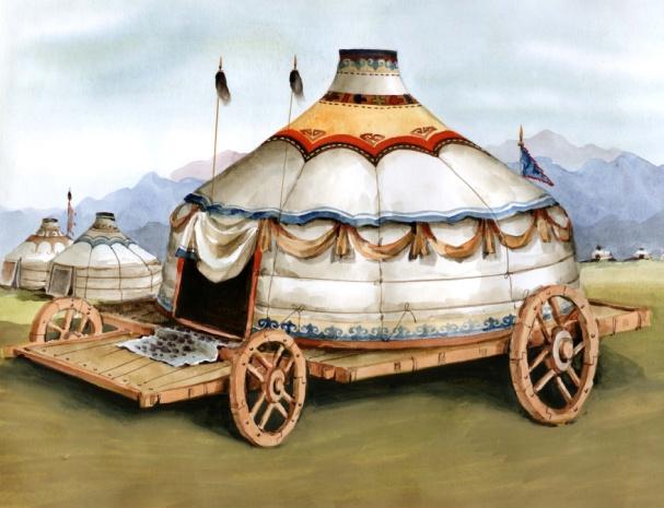
After Islam became the state religion of the Ulus of Jochi during the reign of Khan Uzbek, mosques began to be actively constructed in the cities. There is no doubt that a mosque existed in the camp of Emir Khadjibey. What it looked like can only be guessed now. Most likely, the settlement was a traditional nomadic aul with a large number of dismantlable yurts and a minimum of stationary structures. Mobile yurts mounted on wheeled platforms were characteristic of Turkic and Mongolian nomads. These yurts could sometimes accommodate several hundred people and were often used as mosques. It is likely that the first mosque in Khadjibey was of this type.
After the Battle of Blue Waters, the territory between the Dniester and Dnieper rivers came under the control of the Grand Duchy of Lithuania. In the 1420s, in Kochubey (as Odessa was called then), Prince Vytautas built a stone castle.
 Кocubej-Кoczubej-Кoczubiiw-Kacibej
1415 – 1510(?) – Grand Duchy of Lithuania. Administrative subordination unknown
From the first written mention of Kacibiiw in “Roczniki czyli Kroniki sławnego Królestwa Polskiego” by the Polish historian J. Długosz (1415) to the last one, dated 1472 (the decree of Khan Mengli Giray), Kaczibej was mentioned six times in various documents. All these sources state that the castle during that period belonged to Lithuania and Poland.
Historian Taras Honcharuk, Doctor of Historical Sciences and Professor of the Department of Ukrainian History at Odessa University named after I. I. Mechnikov, has been meticulously studying this historical period for many years. He states that scholars are aware of several documents from that time which mention Kaczubiiw (a Slavicized version of the name Koczubej). The first is an excerpt from the “History of Poland” by chronicler Jan Długosz, which mentions an event that took place on the “green holidays” of 1415. It was then that the Polish King Władysław Jagiellończyk promised the envoys of the Patriarch of Constantinople and the Byzantine Emperor generous assistance with grain, which they could take from his royal port of Kochubiiv. At that time, as Taras Honcharuk emphasizes, this was the only Polish port, as Poland did not have access to other seas. “The source is sufficient, regardless of what others might say, and reliable. Jan Długosz was one of the best Polish chroniclers, and he had no reason to lie about this matter” It is likely that the stone castle of Kachibey was built in 1421, or slightly later. This is indirectly evidenced by the memoirs of the Flemish traveler Ghillebert de Lannoy, who saw a large number of workers and building materials arriving on the banks of the Dniester with the aim of constructing a castle or several castles.
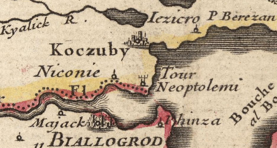 The next two mentions of the “lands of Podolian castles” date back to 1431. By the word “castle,” a fortress was meant, not a feudal estate, historian notes. In 1442, the Polish king gifted Koczubiiw to the Podolian starosta Theodorik Buczatsky (also known as Jazłovetsky). At the same time, a new land, Peresyp, is also mentioned. There, in the list of donated lands, a water customs in Koczubiiw “located on the sea shore” is noted. T. Honcharuk believes that the fortress at that time was most likely located on what is now Primorsky Boulevard.
Historian Nikandr Molchanovsky characterized the policy of the Grand Duchy of Lithuania in the Black Sea region as follows: “Vytautas’s policy towards the Tatars, as far as it concerns the fate of Podolia Ukraine itself, undoubtedly achieved a brilliant, although short-lived success. By weakening the enemy and clearing the ground for his power in Podolia up to the shores of the Black Sea, Vytautas sought to establish strong footholds here in case of new turmoil and upheavals“.
PhD in History Volodymyr Pivtorak also speaks about the “city” (by medieval standards) with a fairly active life. This is evidenced by archaeological finds, such as coins and ceramics from the 14th-15th centuries, discovered on Primorsky Boulevard. “It was a fortified point with several towers, covering an area of about 0.7 hectares. Its size can be compared, for example, with the citadel of the Bilhorod-Dnistrovskyi fortress” The military garrison of the small fortress consisted of 10-15 mounted knights, their servants, totaling up to 50 people. “This was enough at that time to protect such a military object“, says the historian. As for the population around the fortress, Volodymyr Pivtorak suggests it could have reached up to 500 people. Regarding the ethnic composition of the population, it was quite diverse, according to Volodymyr Pivtorak: “Most likely, there could have been Italians from Genoa. Probably, Armenian merchants, because we know that they lived in all major trading centers of that time like Kamianets, Caffa, and Lviv. Undoubtedly, Podolian Ruthenians, and the nobility there – knights, were also Ruthenian nobility, those who later were more actively referred to as ‘Ukrainians.’ Tatars were probably either military or nomads who could have been wandering around” At the end of the 14th century, the Tatars were mostly driven out by Lithuanian prince Vytautas through the area between the Dniester and the Dnieper, with some of them entering Lithuanian service. In 1421, diplomat and traveler Gilbert de Lannoy reported in his diary about the Lithuanian Tatars living in the area near Hadzhybei: “I crossed the Dniester, the Dnieper, where I found a Tatar prince, a friend and servant of the Grand Duke Vytautas, and also a large village inhabited by Tatars, subjects of Vytautas. Men, women, and children had no houses and were placed directly on the ground. This prince, named Zhambo, offered me a lot of sturgeon fish and gave me a meadow buttercup juice to prepare it and treated me well. Then he ferried me, my people, and my carts with the help of his Tatars to the other side of the river, which was a league wide, in an amazing way, in small boats made from a single piece of wood” De Lannoy was not too knowledgeable about the intricacies of Tatar life and customs. Those “placed directly on the ground” had probably migrated to the Dnieper shortly before the diplomat’s arrival and simply hadn’t set up their yurts yet. The Tatars met by the Flemish diplomat were Muslims who continued to live on their lands under the rule of Prince Vytautas.
Volodymyr Pivtorak suggests the presence of a small stone church for 20-30 people, similar to the Greek Church of John of Suceava, preserved in Bilhorod-Dnistrovskyi. Possibly, besides the Christian church, there was also a mosque. When talking about Koczubiyiw as a port through which a large amount of grain was to be shipped, it had to accommodate people who transported and loaded it onto ships: “On the Golden Horde trade routes of the 13th-14th centuries, caravanserais were common. I can hypothetically assume that we might have had something similar, as it would be difficult to organize the constant stay of people for several nights while they unloaded. However, the grain caravans themselves were adapted for living in the field conditions – they could set up sleeping places around the campfire, and that was sufficient”. The area around Koczubiiv was generally unsuitable for active farming. Deep plowing had to be organized, but the technical capability to do so was not available at that time. The same wheat started to be actively planted much later, and in those times, it was only brought from northern regions. Consequently, rural population, as we imagine it, was not large, the historian speculates.
 Ginestrа
Somewhere at the end of the 14th century, the Italian trading factory of Ginestra appeared. Like the ancient Greeks, the Italians exported grain and slaves from the Black Sea region. We can judge the location of Genoese colonies by the preserved navigational maps of sailors – portolans. On the portolans, Ginestra occupies the place of the current historical part of Odesa. Ginestra was a small anchorage for passing trading ships. The exact meaning of the name “Ginestra” is still not determined. The 19th-century Odesa scholar F.K. Brun translated it from Italian as “broom” (a type of plant). Others believe the name resembles a modified word “Dniester.” Candidate of historical sciences, medievalist (specialist in the Middle Ages) Oleh Luhovyi notes: “Ginestra was constantly marked on nautical charts of the 14th-15th centuries and beyond, so ships did stop there. This means there was some infrastructure. We have no information about its size or scale. The maps show a point where there is some infrastructure where one can dock. It was possible to replenish supplies of fresh water, for example, and purchase provisions for further travel before the next stop – Moncastro, that is Akkerman, as the stop before it was precisely here“.
The Withdrawal of the Grand Duchy of Lithuania from the Northern Black Sea Region
After 1472, Kacibej is not mentioned anywhere else until the beginning of the 16th century. However, it is known that in 1492, Mengli Giray established a new fortress, Achik-Kale (Ochakiv), on the site of the Lithuanian fortress Dashiv.
From this, one can conclude that between 1472 and 1492, the Grand Duchy of Lithuania lost access to the Black Sea. The most likely date for this event is 1482, during the campaign against Kyiv. It is quite logical that Mengli Giray, preparing for active confrontation with Lithuania, took into account the presence of several Lithuanian castles in close proximity to his territories. Primarily, these were Dashiv and Kachibey. Leaving them in his rear would have been dangerous.
Incidentally, the fact that in 1482 the key points of the Lithuanians between the Dniester and the Dnieper rivers fell is evidenced by the following events. In 1484, Ottoman Sultan Bayezid II waged a campaign against the Principality of Moldavia. In August, he besieged the fortress of Chetatya Albe (Ak-Kerman, Bilhorod-Dnistrovskyi, Moncastro). His ally Mengli Giray came to his aid with a 50,000-strong army. To reach Ak-Kerman, Mengli Giray had to cross the territories of the Grand Duchy of Lithuania.
 It is evident that by this time, all Lithuanian castles were either destroyed or under Tatar control. Additionally, it is known that during this period, the borders between the Crimean Khanate and the Ottoman Empire were established along the Dniester River. Attention should also be paid to the remarks of F. Petrun, who, discussing the ownership of the area between the Dniester and the Dnieper rivers, wrote that Lithuanian and Polish feudal lords “abandoned this region no later than the 1480s” It was not in vain that ten years later, the Tatars built a small fortress, Ochakiv (Ozhyu), on the site of the Lithuanian town of Dashiv.
By the end of the 15th century, the policy of the Polish king and Grand Duke of Lithuania, Kazimierz IV Jagiellończyk, in the Northern Black Sea region had completely failed. For centuries, the lands of southern Ukraine became a zone of constant military conflicts.
By the end of the 15th century, the port of Kachibey had declined, especially after the Ottoman capture of Constantinople in 1453, which blocked the passage through the Black Sea straits for Genoese and Venetian ships. The Grand Duchy of Lithuania was no longer able to defend its distant and sparsely populated lands. Eventually, the Ottoman Empire and the Crimean Khanate captured the area between the Dniester and the Dnieper rivers.
(Click on the banner to read more)

___________________
according to materials:
resource https://islam.in.ua/, author – O.Stepanchenko,
resource https://odessa-life.od.ua/, author – Iu.Cushchenko
resource https://ukrainopedia.fandom.com/
resource https://resource.history.org.ua/
resource “Odesaznavstvo”
_______________________________
The text was translated from Ukrainian by Artificial Intelligence