Previous section (click the link to return):
←2.1.Kotsubey (Kochubiyiv). Period XV century. Eastern Europe II-XV centuries♦
←1.1.Ancient cities in the place of modern Odesa♦
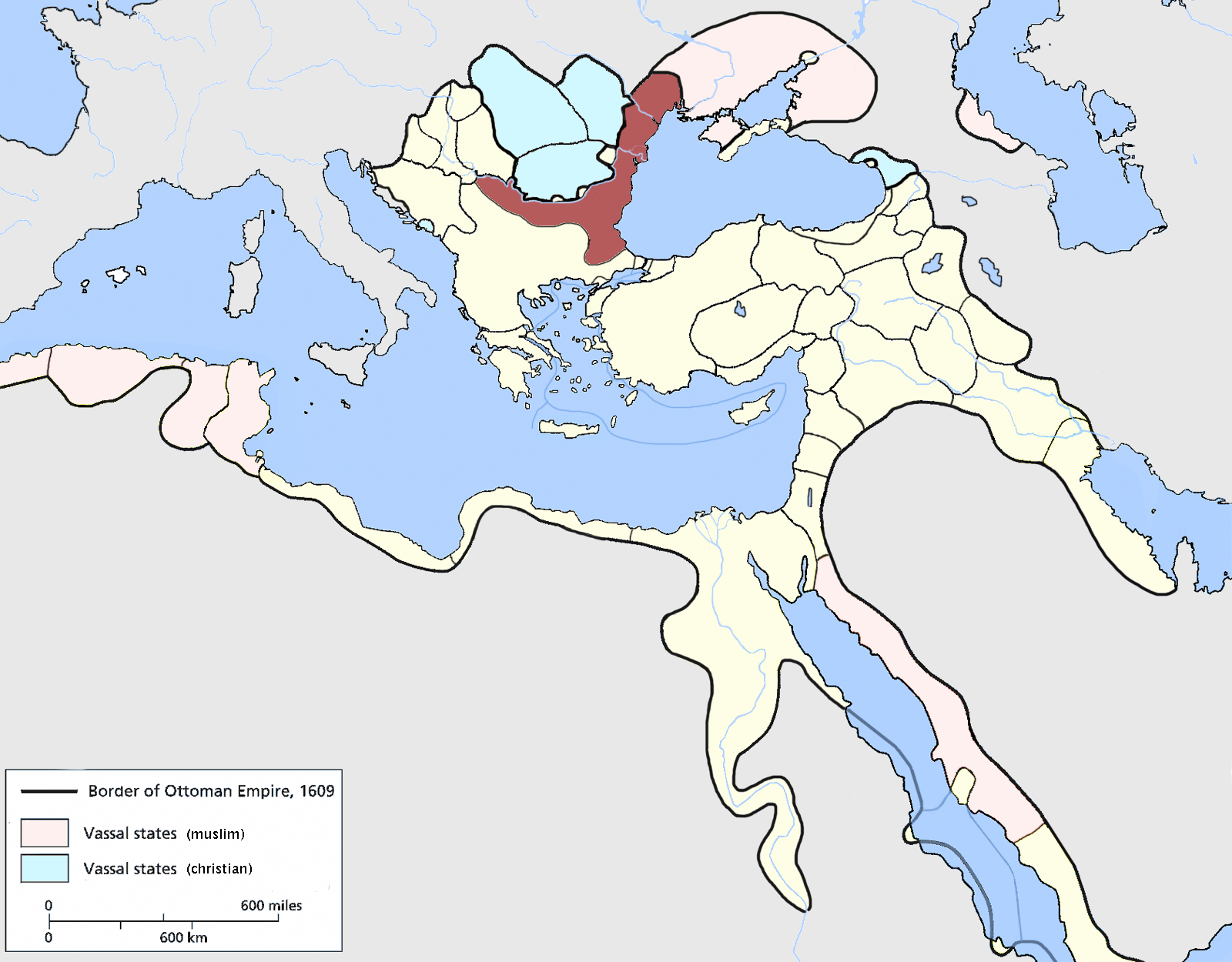
Ottoman Expansion
 Under the rule of Mehmed II, the Ottoman Empire resumed its active expansion, which lasted for two and a half centuries. Mehmed II’s capture of Constantinople on May 29, 1453, granted the empire strategically crucial control over the Bosporus and Dardanelles straits, a splendid capital, and elevated the international prestige of the state and dynasty. The conquest fulfilled longstanding ambitions of the Islamic world and heightened the sultan’s own aspirations as a world conqueror. Mehmed II adopted not only the epithet Fatih (“Conqueror”) but also the highest titles of sovereign rulers of the world—khan, caesar (kaiser, tsar), padishah. Ambitions of global domination were the main driving force behind his expansionist policy. Mehmed II took control of almost the entire Balkan Peninsula, introducing a unified imperial administration there. The principalities of Moldavia and Wallachia were brought into vassalage, and the Crimean Khanate was subordinated. The conquest of the Empire of Trebizond (in 1461), the Italian colonies in Crimea in 1475, and during the reign of Bayezid II, the fortresses of Kilia and Akkerman (now Bilhorod-Dnistrovskyi) in 1484 gave the Ottoman Empire control over the Black Sea and the resources of its coast. These became the main supply resource for Constantinople (Istanbul).
The Crimean Khanate
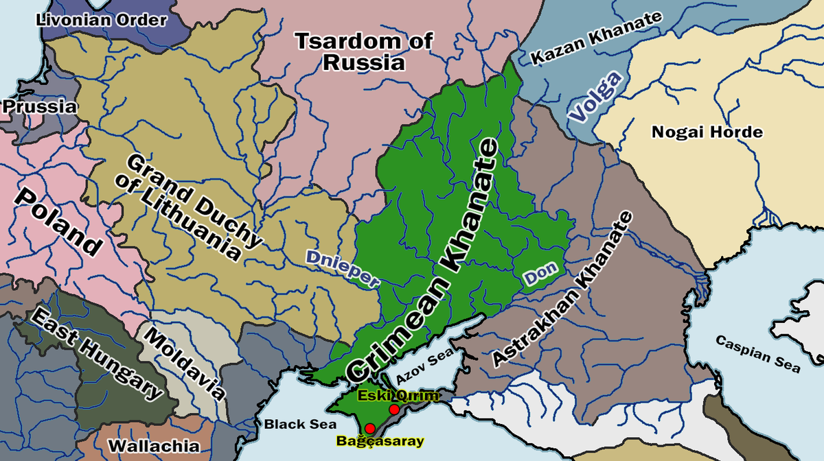 Apart from the Crimean Peninsula, the steppe territories of the Northern Black Sea region, inhabited by nomadic tribes, mainly Nogais, were under the rule of the Crimean khans in various forms of dependency. These included the “Or-tashrasi” (“Trans-Or”, “Land beyond Perekop”), as well as certain territories of the Kuban region and the North Caucasus, inhabited by Nogais, Circassians, and Abkhazians.
The formation of the central territory of the state began in connection with the Mongol conquest. According to Plano Carpini (1246), the interfluve of the Dnieper and Don was given to Mavuchi (Modji Yaya; the second son of Chagatai, grandson of Genghis Khan) to govern. This territory, as a separate domain, was later allocated by the Khan of the Golden Horde, Mengu-Timur (1267–1280), as a nuntukh (appanage) to his son Urang-Timur. From this time, the territory became known as the “Crimean land” (from the name of the vicegerent’s headquarters – Crimea; this word likely meant “ditch”; another name for the headquarters was Solkhat; now the city of Stary Krym). At the beginning of the 14th century, the Crimean ulus had the status of a tumen of the Golden Horde, i.e., a vicegerency that could raise 10,000 troops.
In the early 1430s, Hacı I Giray reached a certain consensus with the Golden Horde clans settled in Crimea. In 1445, he formed an alliance with the Grand Duke of Lithuania, and from 1447, also with the Polish King Casimir IV Jagiellon. In August 1449, Hacı I Giray formally declared himself the independent ruler of Crimea, while still maintaining claims to the Golden Horde throne. He defined the status of his territories as “ulug ulus” (“great ulus,” meaning sovereign ulus). He defeated the Golden Horde Khans: in 1452 in Podolia and in 1466 on the Don River.
The search for allies against Caffa and the Golden Horde pushed Hacı I Giray to ally with the Ottomans, who had been active on the northern coast of the Black Sea since 1446. However, after Hacı I Giray’s death, his son Khan Nur Devlet pledged allegiance to the Golden Horde Khan Akhmat. Another son, Mengli I Giray, was hostile to Akhmat and thus sought an alliance with the Ottomans (his letter to Sultan Mehmed II in 1469 is well known). In 1476, due to a power vacuum, Janibek, a protege of Golden Horde Khan Akhmat, took control in Crimea. Internal anarchy and the threat of the Golden Horde reasserting control over the Crimean Ulus forced the Crimean clans to restore Mengli I Giray to the khanate. This also pleased Mehmed II, as Mengli I Giray acknowledged personal allegiance to Ottoman Sultan Mehmed II and confirmed this with a letter in early July 1475. This set a precedent for the subordination of the Giray dynasty to the Ottoman house, although no formal treaty ever existed between the two dynasties—Ottomans and Crimean Chingisids. This was facilitated by Mengli I Giray’s long reign and the expulsion of his brothers from Crimea, ensuring the succession only through Mengli I Giray’s line.
 After returning to power, Mengli I Giray renounced the alliance with the Grand Duchy of Lithuania and established an alliance with Grand Prince of Moscow Ivan III Vasilyevich. As a result of their joint actions, the allies repelled the attack of the Golden Horde Khan Akhmat on the Grand Duchy of Moscow in 1480. The defeat of the Golden Horde caused a rebellion against Akhmat, during which he was killed in 1481. Following this, Mengli I Giray assisted the Grand Princes of Moscow, Ivan III Vasilyevich and Vasily III Ivanovich, in their wars against the Grand Princes of Lithuania, and he himself began to conduct raids on Ukrainian lands that were part of the Grand Duchy of Lithuania. At the same time, he fought alone against Akhmat’s descendants, conquered Astrakhan (now a city in Russia) in 1502, and this marked the end of the Golden Horde.
The relations between the Crimean Khanate and the Ottoman Empire were based not on the right of conquest but on the right of interdynastic union, according to which the Gireys recognized the supremacy of the Ottomans, including the right of the latter to appoint and remove Crimean khans. The Crimean khans had all the formal attributes of sovereignty recognized in Islamic law, namely: the right to mint their own coins and the right to khutbah (sermons in their honor during the congregational afternoon prayer on Fridays). Only starting with Islam II Giray (1584–1588), who created a precedent by refusing to have his name mentioned first during khutbah, were the names of Crimean khans mentioned in khutbah after the sultan’s name. Judicial proceedings according to the prescriptions of Islamic law (Sharia), common to both the Ottoman Empire and the Crimean Khanate, were carried out in Crimea by judges (qadis) appointed by the office of the qadiasker of Rumelia (at that time covering, besides Bulgaria, modern Macedonia, the northern part of Greece, part of Serbia, Albania, Bosnia and Herzegovina, and part of modern Turkey) in Istanbul. However, sultanic law (kanun) did not apply to the Crimean Khanate. Traditional law (adat or töre) was in force here. Khan Murad Giray (1678–1683) even attempted, though unsuccessfully, to introduce judicial proceedings exclusively according to töre norms.
In the titulature of the Crimean khans, their state was metaphorically called “Takht-i-Krym” (“Crimean Throne”) or “Takht-i-Krym ve Desht-i-Kipchak” (“Throne of Crimea and the Kipchak Steppe”). From 1502, the khans also used the imperial title “padishah,” but did not use it in their relations with the Ottoman sultans. In the first half of the 16th century, the Crimean khans claimed the role of heirs to the entire Chinggisid Empire as “emperors of all the Mongols” (barça Mogol padişahı). The state of the Crimean khans was referred to by the Ottomans and their European neighbors as the “Crimean Khanate” (after the capital city of Crimea/Solhat). Europeans also called it “Little Tartary” in contrast to “Great Tartary”—the Eurasian Steppe and the Chinggisid Mongol Empire. In the Polish-Lithuanian Commonwealth, it was called “Perekop Tartary” (Tartaria Praecopensis, Tartaria Precopensis) and the “Perekop Horde” (after the city of Crimea, later the border fortress of Or – “Perekop”). The Grand Dukes of Lithuania and Moscow recognized the imperial status of the Crimean khans and titled them “Crimean tsars” (or “Perekop tsars,” Caesar Praecopensis). From the mid-16th century, the full title of the Crimean khan was standardized as “Ulu Orda ve Ulu Yurtniŋ ve taht-i Krim ve Deşt-i Kipçakniŋ ve cumle Tatar ve bi-hesab Nogayniŋ ve Tat ve Tavgaçniŋ ve Dağ Çerkaçniŋ ulu padişah” (“Great padishah of the Great Horde, Great Yurt, throne of Crimea and the Kipchak steppe, all Tatars, innumerable Nogais, Tats, Tavgachs, and mountain Circassians”). Informally, the khans and their subjects referred to their state as “Krym yurt” (“Crimean domain”).
 The special legal status of the Crimean Khanate in its union with the Ottoman Empire was also evident in the fact that the khanate was not included in any imperial customs zone. Therefore, goods, including slaves, crossing the Ottoman-Crimean border were subject to import duties on both sides as imported goods. During their reign, the khans were the full sovereigns of the Crimean Khanate, having the right to conduct independent foreign relations, appoint and collect taxes, issue laws, and more.
From the last third of the 17th century, the Ottoman state managed to bring the Crimean Khanate under much stricter control. This was prompted by, firstly, failures in their own defense in Hungary, and secondly, the activation of the expansionist policy of the Russian state in the Northern Black Sea region after its alliance with the Ukrainian Cossacks. The khans gradually lost their foreign policy initiative and had to enter into alliances made by the Ottoman Empire. Thus, the strategically important alliance for the Crimean Khanate with the Polish-Lithuanian Commonwealth, directed against the Russian state, was abandoned following the acceptance of Ottoman suzerainty by the Ukrainian hetman Petro Doroshenko and the participation of the Polish-Lithuanian Commonwealth in the anti-Ottoman “Holy League”. Meanwhile, the Crimeans almost annually conducted campaigns in Hungary and Transylvania (a historical region in northern Romania) in the interests of the Ottoman Empire. At the same time, the Russian army and the Zaporizhian Cossacks reached Perekop during the Crimean campaigns of 1687 and 1689. In 1695, the Crimean Khanate lost its fortresses in the lower Dnieper region. To compensate for the loss of Azov in 1696, the Ottomans built the fortress Yenikale and strengthened Ochakov.
One of the last manifestations of the independent policy of the Crimean Khanate was the plans of Devlet Giray II (1708–1713) to join the alliance of the Ukrainian Hetman Ivan Mazepa with the Swedish King Charles XII (Peter I’s victory at the Battle of Poltava in 1709 thwarted these plans), as well as the acceptance of the Zaporizhian Cossacks, who founded the Oleshky Sich on the lands of the Khanate, and the recognition of the Crimean Khanate as the guarantor of the freedoms of the Zaporizhian Host according to the constitution of Pylyp Orlyk.
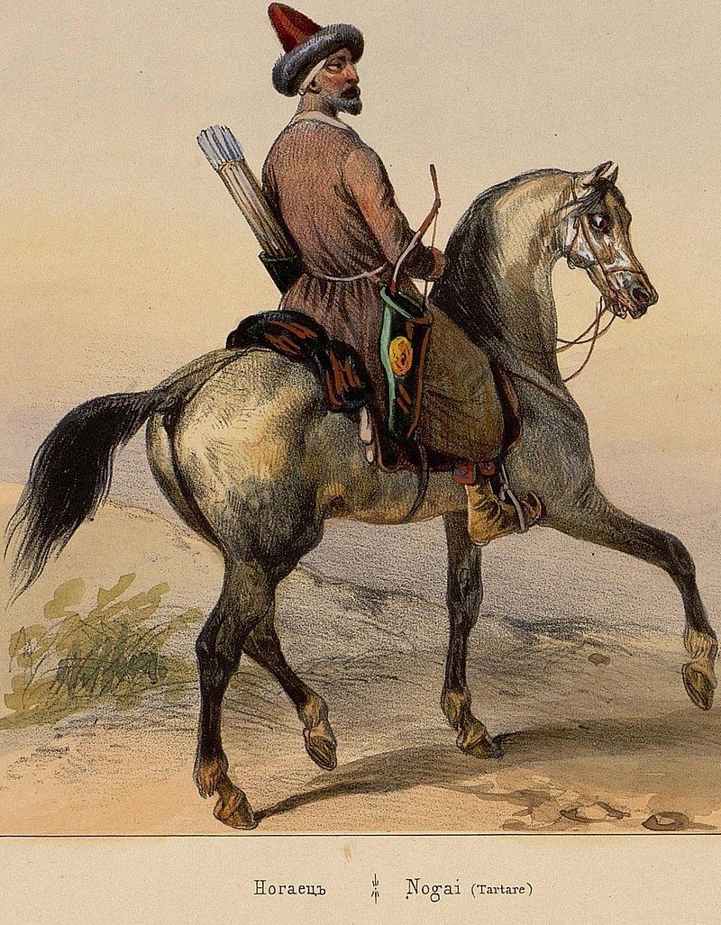
The Nogais
 The Nogais were a late nomadic state that united nomads from the lower Volga and Ural regions during the dissolution of the Golden Horde. Emerging in the late 14th to early 15th century under the leadership of Bey Edigei (Edigü), it solidified its formation definitively in the 1440s under his son Nuradin. The ethnic composition of the Nogai Horde (Nogais) initially had a substrate of Polovtsian-Kipchak origin, assimilating Mongolian and other ethnic communities (Mangits, Kireits, Naimans, Kipchaks, Kangly, Oymaks, Burquts, Kungurats, among others) migrating from Central Asia to the Volga in the 13th century. They were classified under the Kipchak subgroup of the Turkic Altaic language family. Within the hierarchy of aristocratic clans, the Mangit clan, to which the founder of the Nogai Horde Edigei and his descendants belonged, occupied a prominent position. Initially known as “Mangit Yurt,” the population and territory of the Nogai Horde adopted the ethnonym “Nogais” derived from another name of Edigei – Nogai.
 During the late 16th to the second quarter of the 17th century, a significant portion of Nogais from various groups migrated to the Northwestern Black Sea region, coming under the control of the Crimean Khanate and the Ottoman Empire, forming the separate Budjak Horde (Bilhorod Horde) centered in the village of Hankishla (now Udobne in Bilhorod-Dnistrovskyi district of Odessa region). In the first third of the 18th century, migrations of Yedisan, Jambuluk, and Yedichkul Nogais to the Northern Black Sea region took place. Following the Russo-Turkish War of 1735–1739, the settlement boundaries stabilized between the Yedisan Horde (steppe between the Dniester and Dnieper rivers) and the Jambuluk Horde (left-bank steppe of the Dnieper up to the Kinska and Berda rivers). In 1759, the Yedichkul Horde was settled south of the Dnieper marshes and on the left bank of the Kinska River. Together with the Budjak and Kuban Hordes, it remained under the authority of the Crimean Khanate.
 The Budjak Horde (also known as Bilhorod Horde, Dobruja Horde, or Lesser Nogai Horde) was a union of semi-nomadic Nogai tribes that formed in the second half of the 14th century and occupied the steppes between the mouths of the Dniester and Danube rivers from Bilhorod (now Bilhorod-Dnistrovskyi) to Kiliya. The steppes stretched over 200 km in length and approximately 150 km in width. By the late 15th century, this territory came under the rule of the Ottoman Empire. In 1569, 30,000 Astrakhan-Nogai families resettled from the Caspian steppes to this region, eventually becoming known as Budjak Tatars. The name derived from the town of Budjak (now a settlement) on the Dniester estuary, which served as their main administrative center. Mass migrations of Nogais to the Bilhorod (Budjak) steppes began in the early 17th century, driven mostly by poor Nogai Tatars fleeing hunger. The Budjak Horde was in vassal dependency on the Crimean Khanate, while Akkerman (modern-day Bilhorod-Dnistrovskyi) and its surrounding lands along the Black Sea, the Danube lands around Kiliya, Izmail, together with Bender (now a city in Moldova), were under Turkish suzerainty. Key centers of the Budjak Horde included the fortress town of Akkerman, the town of Kaushany (now in Moldova), where the residence of the Crimean Khan was located during his stay in the Budjak Horde, Budjak town, the small fortress of Palanka on the Dniester, Tatar-Bunar (Kara-Bunar, Karbona) on the Kagach River (now Tatarbunary in Ukraine), Tobak near Lake Yalpug (now Tabaki village near Bolhrad in Odessa region), and Salkutsa settlement on the Botna River (now in Moldova). The majority of the population lived in uluses (nomadic camps), which numbered between 80 to 90 uluses at various times. The region was governed directly by murzas. The Budjak Tatars were primarily engaged in horse breeding, raising cattle, sheep, and growing wheat, rye, barley, millet, occasionally vineyards. Due to the low level of development of productive forces, the Bilhorod Nogais struggled to sustain themselves and resorted to raiding neighboring lands for sustenance. In the first half of the 17th century, the Budjak Horde could mobilize between 15,000 to 30,000 people for military campaigns.
A particularly aggressive ruler of the Budjak Horde was Kantemir Murza, who frequently led attacks on Podillya, Galicia, and Volhynia. After the Battle of Hotin in 1621, Ottoman Sultan Osman II appointed Kantemir as the Pasha of Ochakov, Silistra (modern-day Silistra in Bulgaria), and Babadag (modern-day Babadag in Romania), entrusting him with the defense of the Turkish-Polish borderlands and placing him under direct Turkish patronage. As a result, Kantemir ceased to recognize vassal dependency on Crimea. Turkey used the Budjak Horde, led by Kantemir, to subdue defiant khans in Crimea and directed them to invade territories of the Polish-Lithuanian Commonwealth, primarily Ukrainian lands. In 1628, Kantemir Murza was granted the title of vizier – ruler of the Black Sea coast and the mouth of the Danube, including Silistra and Akkerman. This led to his intervention in the internal affairs of Crimea, increasing tensions between Crimean and Bilhorod murzas. Subsequent rulers of the Budjak Horde sought to rid themselves of the authority of both the Crimean Khan and the Turkish Sultanate. Following the Russian-Turkish war in 1768-1774, the Budjak Horde acknowledged the protectorate of the Russian Empire in 1770, resettling in the Azov steppes between Kamianka and the city of Azov. The Bilhorod steppes were handed over to the Crimean Khanate. The Bender Pasha, benefiting from the proclamation of the Crimea’s independence from Turkey (in 1774), took possession of the area. After the Crimean War of 1853-1856, most of the Budjak Horde emigrated to Turkey.
The Yedisan Horde (also known as Jedisan Horde or Ochakov Horde) was a branch of the Lesser Nogai Horde. The term “Yedisan” derived from a specific military unit of the Horde – approximately 7,000 archers (in Tatar, “yedisan” denotes this number of archers that the Horde once had). As part of the Nogai Horde, the Yedisan Horde roamed the steppes between the Volga and Yaik (now the Ural River). From the mid-17th century, it was subordinated to Khan Ayuka, and in 1715, it resettled in Kuban, later moving to Southern Dnieper Region. In 1723, it acknowledged the sovereignty of Turkey and the Crimean Khanate and concentrated on the Black Sea lands between the Dnieper and Dniester rivers, from the Black Sea coast to the Kodima River (a tributary of the Southern Bug). The main settlement of the Yedisan Horde was around the Turkish fortress of Ozi (Ochakov). Hence, another name for the Yedisan Horde is the Ochakov Horde. Ochakov and the surrounding area between the Buzhsky Liman and the Deligol (now the Tiligul River) were directly subordinate to the Ottoman administration, while the rest of the territory where the Yedisan Horde resided was under the rule of the Crimean Khan.
Compared to other hordes, the Yedisan Horde was the largest in terms of population. In 1766, it numbered around 40,000 yurts. The horde was led by a kaimakan or seraskir from the Giray family appointed by the Khan, with direct administration by murzas. The population engaged in hunting, horse breeding, cattle, sheep, and the cultivation of millet, barley, and buckwheat. The ruling elite constantly involved the male population of the horde in raiding attacks on Ukrainian, Russian, Polish, and other lands, as well as in wars waged by Turkey. In the mid-18th century, the Yedisan Horde gained political significance and even intervened in the internal struggle of the Girays for the Crimean Khanate throne. During the Russian-Turkish War of 1768-1774, the Yedisan Horde acknowledged the protectorate of the Russian Empire (in 1770) and was soon resettled into the steppes stretching from the Kamianka River to the city of Azov, and later to the interfluve of the Don and Kuban rivers. After the Crimean War of 1853-1856, the Yedisan Nogais resettled into the possession of the Ottoman Empire (partially into the steppes of Southern Bessarabia and partially into Asia Minor).
 Jambuiluk Horde (Perekop Horde) – a branch of the Nogai Horde. Founded by Nogais who resettled from the South Caucasus steppes in the second half of the 16th century. They roamed on the left bank of the Dnieper River between the fortress city of Perekop (the main center of the Jambuiluk Horde, sometimes referred to as the Perekop Horde; now a village subordinate to Armenian City Council in the Autonomous Republic of Crimea) to the south, Kinburn to the west, the Dnieper River, and the city of Kazikermen (modern-day Berislav) on the north – the Berda River and further eastwards through the steppe. The horde lived in auls, consisting of families or yurts (in 1766 there were 5,000 yurts). The horde was ruled by a kaimakan, occasionally a seraskir-sultan from the Giray dynasty, who always resided in Perekop. The fortress of Perekop was rebuilt by Crimean Khan Sahib Giray I (1532–1551) who, during his rule, restored the walls on both sides of the fortress, filled them with seawater, and maintained a constant garrison. The Jambuiluk Horde was in vassal dependence on the Crimean Khanate and was obliged (at the Khan’s demand) to participate in raids of Crimean Tatars on Ukrainian, Russian, Polish, and other lands. During the Russian-Turkish War of 1768-1774, the Jambuiluk Horde acknowledged the protectorate of the Russian Empire. In 1771, they were resettled to Kuban, and in 1790, to the steppe lands of the Azov Sea. After the Crimean War of 1853-1856, the Jambuiluk Nogais emigrated to the Ottoman Empire.
Yedichkul Horde – a branch of the Lesser Nogai Horde. From the second half of the 16th century, they roamed in the steppes between the Dniester and Danube rivers. The name derives from “yedi” – seven and “kul” or “kol” – lake, literally meaning “seven lakes horde”. They were subordinated to the Crimean Khanate. The main rulers of the Yedichkul Horde were seraskir-sultans from the Giray dynasty and yali-agas who collected tribute for the Khan. Murzas ruled in the auls, subordinate to the seraskir-sultan. The population of the Yedichkul Horde engaged in nomadic animal husbandry. Significant for the livelihood of the horde were raiding attacks on neighboring lands, primarily Ukrainian ones. Over time, the Nogai hordes began to show complete disobedience to the Girays, which led to sharp conflicts. United forces of Turkish seraskirs and the Crimean Khan opposed the hordes. In 1766, the Yedichkul Horde had 100 auls, each with 100 to 200 or more yurts, totaling 29,000 yurts. During the Russian-Turkish War of 1768-1774, the Yedichkul Horde acknowledged the protectorate of the Russian Empire (in 1770) and was soon liquidated. The Yedichkul Nogais were resettled to Kuban in 1771 and to the Azov steppe in 1790 (near the Molochne River, now the Molochanka River). After the Crimean War of 1853-1856, they resettled into the possession of Turkey.
The Khan Ukraine (Khanshchyna)
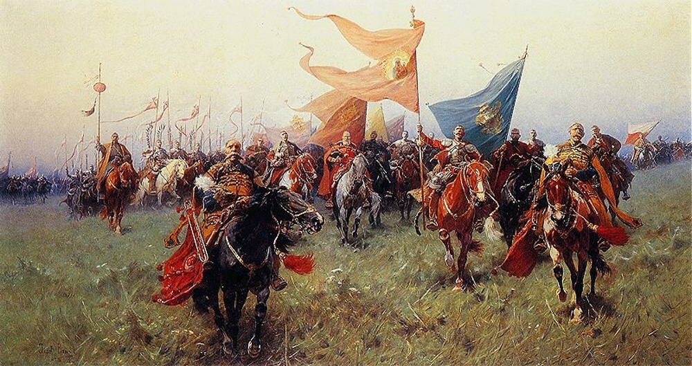 For a long time, historians unjustly downplayed the role of the southern territories of modern Ukraine in its state-building processes. This is not surprising, as the “legitimization” de jure of the separatist Muscovite Left-Bank Hetmanate, which was the focus of Russian and Soviet historical scholarship for centuries, did not allow for thorough research into another state center of the Zaporozhian Host. In reality, the Cossack state under the protection of the Crimean Khanate and the Ottoman Empire had much more claim to the legacy of Bohdan Khmelnytsky than anyone else.
“The lands between the Southern Bug and Dniester rivers have long attracted Ukrainian population“, says Professor Taras Honcharuk from the Odessa National Mechnikov University. “When these lands were under the Ottoman Empire, the Cossacks considered and openly claimed them as their ancient lands up to the Black Sea“.
In the 17th century, the Zaporozhians were true masters of the Black Sea and conducted numerous naval campaigns. The Ottoman Empire was impressed by the scope of these naval wars and attempted to negotiate with the Cossack hetmans.
Associate Professor Alexander Sereda from Istanbul and South Ukrainian Pedagogical Universities emphasizes that diplomatic relations between the rulers of the Ottoman Empire and Ukrainian hetmans can be traced back to 1648. Correspondence began between Sultan Ibrahim and Bohdan Khmelnytsky. A real military-political alliance between Ukraine and the Ottoman Empire became possible in 1669 when Sultan Mehmed IV offered full vassalage to Hetman Petro Doroshenko.
It should be noted that Mehmed came to power precisely because of Bohdan Khmelnytsky, orchestrating a palace coup in Constantinople (the Janissaries-Ukrainians conspired with the future sultan’s mother and killed his father). Mehmed’s mother, Turhan Hatice, was Ukrainian from Poltava region, who wielded certain political influence over her only son. According to eyewitness accounts, Mehmed IV “resembled a Cossack in appearance”.
However, Petro Doroshenko’s authority was severely undermined by the geopolitical maneuvers of Muscovy and the Polish-Lithuanian Commonwealth. The Polish-Cossack-Tatar War of 1666-1671, the Polish-Ottoman War of 1672-1676, and the simultaneous Muscovite-Ukrainian War of 1665-1676 exhausted, devastated, and depopulated Ukraine. This period in our history would later be known as the Ruin, concluded by the Muscovite-Ottoman War of 1676-1681. The resulting Treaty of Buchach effectively divided Ukraine into three parts—Moscow, Polish, and Khan’s. It’s hard to even imagine the scale of the consequences of this catastrophe that befell Ukraine……
On March 11, 1668, at the General Council of the Zaporozhian Host near Korosten, they officially proclaimed “submission to the Sultan” similar to the dependence on the rulers of the Principality of Wallachia and Moldavia. The state of the Zaporozhian Host became part of the Ottoman Empire, and Doroshenko received the title of Bey of the Ukrainian Sanjak from the Turkish Sultan Mehmed IV.
“We can speak of the existence of the Khanate of Ukraine at the end of the 17th century“, notes Alexander Sereda. “Since 1699, the Ottoman government resettled Ukrainian Cossacks in territories controlled by the Crimean Khanate and the Ottoman Empire“.
From the outset of the formation of the Khanate of Ukraine as an administrative-territorial unit, Ukrainian Cossacks settled around the city of Dubossary. Over time, the number of Cossack settlements increased along the rivers Yagorlyk and Kodyma to the Southern Bug. Under Ottoman rule, Ukrainian Cossacks founded dozens of villages and towns where predominantly non-Muslim Ukrainians lived, while Jews, Greeks, Armenians actively traded there, and Russian Old Believers sought refuge. These lands began to be called the Khanate of Ukraine or Tatar Wallachia.
In the mid-18th century, the Ottoman government established four districts with Ukrainian populations, covering the territories of modern Podilsk in Odessa region, Balta, Ananyiv, urban-type settlement Kryve Ozero, and the city of Pervomaisk, two district centers in Mykolaiv region, etc.
The first district was centered in Dubossary, the second in Balta, the third in present-day Pervomaisk on the Southern Bug, and the fourth on the lower Dniester, near the modern settlement Mayaki.
The Khan Ukraine was governed by hetmans from the residence in Yagorlyk near Dubossary, so they were often referred to as Dubossary hetmans. At the end of the 17th century, the baton was held here by Theodore Sulimenko, Yakym Samchenko, Stepan Lozinsky (Stetsik), and the leader of the Khanate of Ukraine was Petro Ivanenko, known as Petryk (a mocking nickname “Petryk” stuck thanks to Moscow sources).
After the deaths of Kostya Gordienko and Philip Orlyk, the position of the Hetman of Hаn’s Ukraine (“Dubossar Hetman”) was merged with the position of the Nogai Horde’s kaymakam. However, in 1765, the new Khan Selim III Giray reinstated it and appointed Jakób Rudziewicz (Yakub-agha) as the Dubossar Hetman. His residence became the town of Balta. Yakov Rudziewicz renounced the mace and received the rights of a Russian nobleman and the rank of a state councillor only in 1783. Thus, he was the last leader of Cossack Ukraine, which survived both the Left-Bank Hetmanate and the Zaporizhian Sich, remaining faithful to the traditions of Bohdan Khmelnytsky, Petro Doroshenko, and Philip Orlyk.
After the annexation of the territories of the Khan Ukraine and the former Free Lands of the Zaporozhian Lower Army (Zaporozhian Sich) to the Russian Empire, they were transformed into the Novorossiya Governorate. Therefore, as Ukrainian historians rightly note, the very existence of the Khan Ukraine refutes the myth of Novorossiya.
“The Khan Ukraine experienced a unique economic development in the 18th century“, says Volodymyr Poltorak, associate professor at the Odessa National Mechnikov University. “During this period, Ottoman merchants purchased grain from this region for Istanbul, and Prussian hussars bought horses for their regiments. The Khan Ukraine represents a distinct form of genuine Cossack statehood.“.
The Ottoman territorial-administrative division of the Northwestern Black Sea region
Formed during the 15th to 18th centuries within the historical-geographical lands comprising modern Moldova and Ukraine. In territories exclusively under Ottoman rule, there was a gradual introduction of the Ottoman centralized territorial-administrative governance system, starting from the formation of the smallest administrative units to the establishment of sanjaks and their subsequent development within the Silistra-Ochakiv Eyalet.
- The establishment of primary administrative management – formation of civil communities for self-governance and their territorial division in Budjak and Ochakiv lands.
- Judicial-administrative management and fiscal-territorial division of the Northwestern Black Sea region.
- Formation of sanjaks in the Northwestern Black Sea region and establishment of the Silistra-Ochakiv Eyalet. In addition to this, on the lands granted to the Crimean Khan, structures of Crimean Tatar administration were established over the hordes, along with the organization of territories predominantly inhabited by Christian populations.
According to archival data, the territory of Northwestern Black Sea in its military-administrative structure was divided into three sequentially created sanjaks: Akkerman, Bender, and Ochakiv, which were part of the Silistra-Ochakov Eyalet. At the early stage of their existence, Akkerman and Silistra sanjaks formed the basis for the establishment of the mentioned eyalet. Each sanjak encompassed several judicial-administrative districts known as kazas. Specifically, the Akkerman sanjak covered the main part of Budjak and the southwestern outskirts of the Ochakiv lands.
The Akkerman sanjak included the kazas of Akkerman, Kiliya, Tatarbunar, and Ismail-Gyeched. The Bender sanjak encompassed the territory of the Kaza of Bender and the lands along the Dniester River of the Ochakiv region. The Ochakiv sanjak covered most of the Bug-Dniester interfluve, excluding the Transnistrian region. Administration by the kadi was conducted over unified communities known as nahiyahs and on designated tax districts called mukataa.
Overall, the main part of the Ottoman holdings in the Northwest Black Sea region was subject to centralized administration under the Ottoman vertical of power, employing a stable territorial-administrative structure of provincial division within the Ottoman Empire. Additionally, the region contained a collection of lands with various forms of administrative organization lacking a unified system of governance, which was based on traditional forms of community organization and typically subservient to the administration of the Crimean Khanate.
Sili̇stre-Ochakiv Eyalet (Ozi-Silistra)
 The administrative unit in the Ottoman Empire in the Northwestern Black Sea region during the period from 1599 to 1864 (from 1792 known as the Silistra Eyalet). It encompassed the territories of Dobruja, Budjak, and Yedisan (in modern-day Turkey, Bulgaria, Romania, Moldova, and within the Odessa, Mykolaiv, and Kherson regions of Ukraine)..
Territorial formation. The Silistra Sanjak was formed based on the territory of the Dobruja Principality, which was occupied by Sultan Mehmed I’s forces in 1396 and finally liquidated in 1420. It was part of the Rumelia Eyalet. In 1484, territories detached from the Principality of Moldavia were incorporated into it, including Kiliya and Chetat-Albu (Akerman, Moncastro; now the city of Bilhorod-Dnistrovskyi), after their conquest by Sultan Bayezid II Dervish. By the end of the 15th century, it included the left bank of the Danube from the mouth of the Ialomita River to the Siret River (a tributary of the Prut River, Danube basin). In 1526, the city of Ochakov was acquired from the Crimean Khanate, in the late 16th century, the city of Koçubey (Khadjibey; now the city of Odessa) from the Grand Duchy of Lithuania, in 1538 – the city of Tyaginya (Bender), from the Principality of Moldavia, in the 16th century – the cities of Babadag and Yeni-Sale from Wallachia.
Administrative division. In 1599, based on the Silistra, Akkerman, Ochakiv, and later Bender sanjaks, the Silistra-Ochakiv Eyalet was established. The reason for its creation was the need for military reinforcement on the border to protect against Cossack raids and to ensure Ottoman sovereignty over the Principality of Wallachia and Moldavia. The first beylerbey (governor) of the Silistra-Ochakiv Eyalet was the Crimean Khan. By the 17th century, the territory of the eyalet expanded, encompassing much of present-day Bulgaria and the European part of Turkey, consisting of 11 kadiliks (judicial districts) and six sanjaks (districts): Silistra, Nikopol (now the city of Pleven Province, Bulgaria), Doğan (now the village of Doganovo in Sofia Province, Bulgaria), Bender-Akkerman (including the cities of Bender, Akkerman, Kiliya, Izmail, and others), Ochakiv (including the cities of Ochakiv, Hadjiderex (Adzhi-Dere, now Ovidiopol), Hadjibey, Dubăsari (now a city in Moldova), and others), Kilburun (now the town of Kinburn). Later, Hadjibey became a separate sanjak. The administrative centers of the Silistra-Ochakiv Eyalet were Silistra (also known as Drastar, now the administrative center of Silistra Province in Bulgaria) and Ochakiv (also known as Dashev, Ozi, Achi-Kale, Ak-Chakum, Kara-Kerman). Some sources indicate that in the mid-17th century, the Silistra-Ochakiv Eyalet was divided into two eyalets – Ochakiv and Silistra. In 1864, the Silistra Eyalet was divided into the Danube (Tuna) and Edirne Vilayets.
The economy of the Silistra-Ochakiv Eyalet was based on agricultural production and export, as well as transit trade. Several provincial codes, known as kanun-namahs, were repeatedly established in the Silistra-Ochakiv Eyalet.
Population and migrations. The population of the Silistra-Ochakiv Eyalet consisted primarily of Crimean and Nogai Tatars, Romanians, Moldovans, and Turks. There were also significant communities of Greeks, Armenians, Jews, Ukrainians, and Roma. In addition to the ethnic Tatars and other Tatarized nomadic populations that had lived in these lands since the 13th century, a portion of the Nogais from the Kuban and Caucasus regions resettled here in 1606. In 1672, by Sultan’s decree, some Budjak Tatars were deported to the territory of the Crimean Khanate. Crimean Tatar and Nogai populations were under dual subordination to the beylerbey and the governor of the Crimean Khanate. The Nogai populations of the Bilhorod Horde and Yedisan Horde were autonomous political entities led by murzas. After 1774 (Treaty of Küçük Kaynarca), a portion of the Kuban and other Nogai populations emigrated to the eyalet, particularly to the Danube Delta, and after the Crimean War of 1853–1856, Crimean Tatars arrived in 1856. Crimean Tatars built new cities, including Medcidie (now Medgidia, Romania), on the ruins of the city of Karasu. In 1708, a group of participants in the Bulavin Rebellion of 1707–1709, known as Nekrasovites, resettled in the Danube Delta within the Silistra-Ochakiv Eyalet. Significant migrations of Ukrainians to the eyalet occurred after 1775 (following the liquidation of the Zaporizhian Sich) and starting from the 1830s from Western Ukraine.
In the 17th-18th centuries, as a result of Cossack raids and wars with the Russian Empire, Wallachian and Moldavian Principalities, the Holy Roman Empire of the German Nation, and repeated occupations (in 1771–1774, 1790–1791, 1809–1810, 1829, and 1853) by Russian forces, the Silistra-Ochakiv Eyalet experienced decline and depopulation due to territorial losses. To address the situation, Sultan’s decree on March 9, 1857, granted privileges to new settlers, leading to the formation of significant communities of Germans, Italians, Balkan Slavs, Bulgarians, Ukrainians, Old Believers Russians, Hungarians, Syrians, and Kurds.
READ MORE→
______________________________
according to materials:
resource http://chm.onu.edu.ua/article/view/268819, Author O. Sereda, Ph.D.
resource http://resource.history.org.ua/,
Authors: O. Bachynska, V. Hrybovskyi, V. Panashenko, O. Kresin, O. Halenko
resource http://www.golos.com.ua/, Author S. Chorna
resource https://armyinform.com.ua/, Author Ie. Buket
_______________________________
The text was translated from Ukrainian by Artificial Intelligence